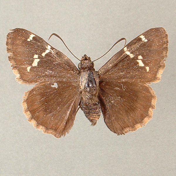
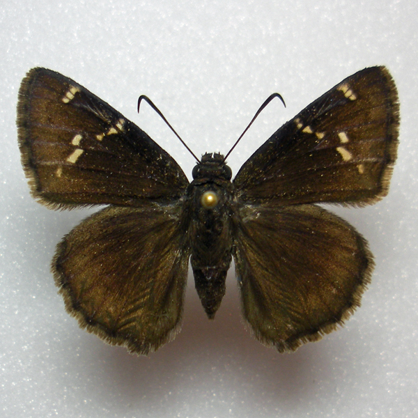
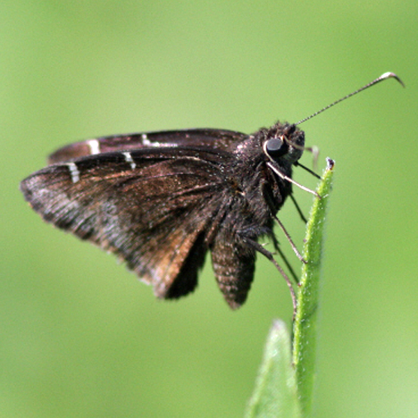
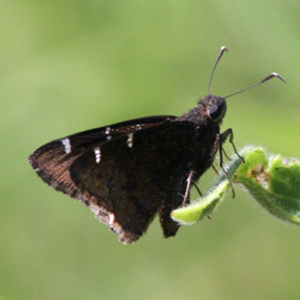
Wing span: 3.5-4.0 cm
Flight time: Most likely three broods, with adults flying from early May to mid August. It appears to be most often encountered in early May, from mid June to early July, and in mid August.
Status: Infrequent breeding resident.
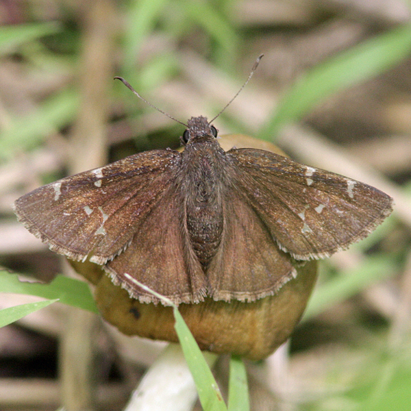
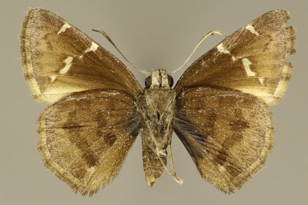
Distinguishing features: This species and Thorybes pylades are quite similar. Both are brown in color with white spots on the upper forewing and have a series of dark brown markings on the lower hindwing. In T. bathyllus, the dorsal white spots are larger and hourglass shaped, the wing fringes tend to be paler, and the dark-brown hindwing bands appear solid rather than hollow. Additionally, males lack the costal fold.
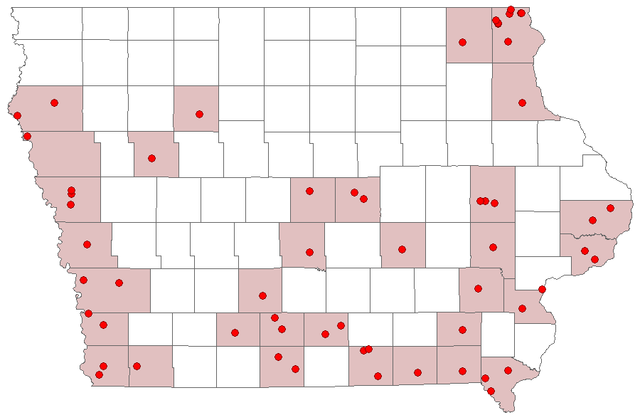
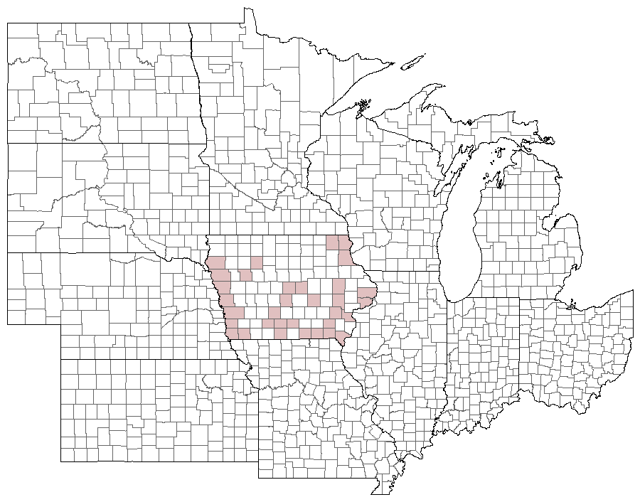
Distribution and habitat: The Southern Cloudy Wing has been observed sporadically across the southeastern half Iowa, with outlying populations also occurring in the Paleozoic Plateau. It is most frequently encountered in xeric grasslands, including Loess Hill prairie, sand prairies, limestone and sandstone glades, and occasionally in old fields.
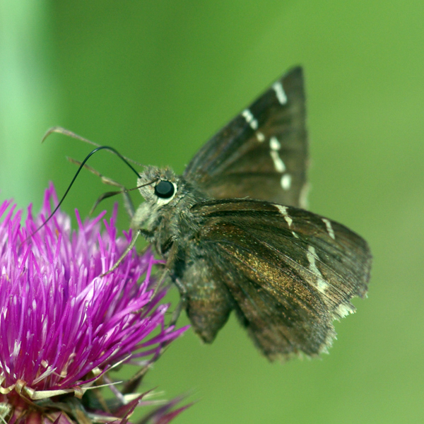
Natural History: The larvae of this species favor wild bean (Strophostyles helvola and S. leiosperma) and Goat's Rue (Tephrosia virginiana), which are most often found in dry, open, and often sandy places. One of the most impressive Southern Cloudy Wing populations occurs on the state's largest Goat's Rue population at the Big Sand Mound in Louisa County. As Goat's Rue is quite uncommon in the state, and essentially limited to the southeast, it is likely that Wild Bean constitutes the more frequent larval host.


| Record # | Date | Locale | State | Lat/Lon | Collected By | Count |
|---|---|---|---|---|---|---|
| 281971 | 2020-06-21 | Shimek State Forest, Croton Unit East | Iowa | 40.545896 -91.616881 | Chris Edwards | 2 |
| 281970 | 2020-06-12 | Stephens State Forest - Cedar Creek Unit | Iowa | 41.059919 -93.177254 | Chris Edwards | 2 |
| 202207 | 2017-08-01 | Decatur County, Iowa | Iowa | Location Protected | Sibylla Brown | 1 |
| 202206 | 2017-07-31 | Decatur County, Iowa | Iowa | Location Protected | Sibylla Brown | 1 |
 68634 68634
|
2014-08-16 | Sedan Bottoms Wildlife Management Area | Iowa | 40.66194444 -92.78888889 | Tom Jantscher | 1 |
| 120407 | 2014-06-16 | Timberhill | Iowa | 40.715921 -93.651635 | Sibylla Brown | 1 |
| 136377 | 2014-06-16 | Decatur County, Iowa | Iowa | Location Protected | Sibylla Brown | 1 |
| 7489 | 2013-08-18 | Decatur County, Iowa | Iowa | Location Protected | Aaron Brees | 1 |
| 7488 | 2011-08-20 | Decatur County, Iowa | Iowa | Location Protected | Aaron Brees | 1 |
 207879 207879
|
2011-08-20 | Decatur County | Iowa | 40.814648 -93.824821 | Aaron Brees | 1 |
| 7490 | 2011-07-24 | Folsom Point Preserve | Iowa | 41.153044 -95.796881 | Aaron Brees | 1 |
 207882 207882
|
2011-06-25 | Five Ridge Prairie State Preserve | Iowa | 42.67867 -96.53473 | Aaron Brees | 1 |
| 119423 | 2010-07-01 | Shimek State Forest, Donnellson Unit | Iowa | 40.643603 -91.67741 | Chris Edwards | 1 |
 207876 207876
|
2010-05-29 | Hitchcock Nature Center | Iowa | 41.416 -95.8495 | Aaron Brees | 14 |
 207877 207877
|
2010-05-29 | Hitchcock Nature Center | Iowa | 41.416 -95.8495 | Aaron Brees | 1 |
 207878 207878
|
2010-05-29 | Hitchcock Nature Center | Iowa | 41.416 -95.8495 | Aaron Brees | 1 |
 207880 207880
|
2010-05-23 | Sylvan Runkel State Preserve | Iowa | 42.1076881 -95.9736997 | Aaron Brees | 3 |
 228048 228048
|
2009-06-19 | Leon's Farm, Ohio County | Kentucky | 37.42033 -86.77023 | Jim Durbin | 1 |
 110245 110245
|
2009-06-13 | Leon's Farm, Ohio County | Kentucky | 37.42033 -86.77023 | Jim Durbin | 1 |
 227674 227674
|
2009-06-13 | Leon's Farm, Ohio County | Kentucky | 37.42033 -86.77023 | Jim Durbin | 1 |
 227714 227714
|
2009-06-13 | Leon's Farm, Ohio County | Kentucky | 37.42033 -86.77023 | Jim Durbin | 1 |
 227741 227741
|
2009-06-13 | Leon's Farm, Ohio County | Kentucky | 37.42033 -86.77023 | Jim Durbin | 1 |
 207881 207881
|
2008-09-06 | Coyote Canyon | Iowa | 41.1213 -93.8614 | Aaron Brees | 1 |
 138476 138476
|
2008-08-06 | Clarke County | Iowa | 41.02903 -93.78516 | Aaron Brees | 1 |
 47748 47748
|
2006-05-29 | Leon's Farm, Ohio County | Kentucky | 37.42033 -86.77023 | Jim Durbin | 1 |
 47747 47747
|
2005-06-06 | Leon's Farm, Ohio County | Kentucky | 37.42033 -86.77023 | Jim Durbin | 1 |
| 63326 | 2002-08-03 | Rock Island Botanical State Preserve | Iowa | 42.02732 -91.72723 | Frank Olsen | 1 |
| 144530 | 2002-08-03 | Rock Island Botanical State Preserve | Iowa | 42.026205 -91.726516 | Frank Olsen | 1 |
| 63319 | 2002-06-28 | Honey Creek State Park | Iowa | 40.86526 -92.94011 | Frank Olsen | 2 |
| 63318 | 2002-06-27 | Honey Creek State Park | Iowa | 40.86526 -92.94011 | Frank Olsen | 2 |
| 63315 | 2002-06-19 | Honey Creek State Park | Iowa | 40.86526 -92.94011 | Frank Olsen | 10 |
| 63316 | 2002-06-18 | Honey Creek State Park | Iowa | 40.86526 -92.94011 | Frank Olsen | 4 |
| 63313 | 2002-06-06 | Honey Creek State Park | Iowa | 40.86526 -92.94011 | Dennis Schlicht | 2 |
| 63314 | 2002-05-26 | Honey Creek State Park | Iowa | 40.86526 -92.94011 | Dennis Schlicht | 1 |
| 63317 | 2001-08-06 | Honey Creek State Park | Iowa | 40.86526 -92.94011 | Frank Olsen | 1 |
| 144178 | 2001-08-06 | Prairie Ridge Park | Iowa | 40.87333 -92.88983 | Frank Olsen | 1 |
| 63321 | 1991-07-06 | Loess Hills Wildlife Management Area | Iowa | 42.08 -95.9765 | Tim Orwig | 1 |
| 63322 | 1989-08-16 | Manikowski Prairie State Preserve | Iowa | 41.972843 -90.375383 | Tim Orwig | 1 |
| 63323 | 1989-08-16 | Manikowski Prairie State Preserve | Iowa | 41.972843 -90.375383 | Tim Orwig | 1 |
| 63324 | 1989-07-15 | Marietta Sand Prairie State Preserve | Iowa | 42.09467 -93.03833 | Tim Orwig | 1 |
 144239 144239
|
1988-06-25 | Wanatee County Park | Iowa | 42.00994 -91.57749 | Frank Olsen | 1 |
| 63330 | 1988-06-02 | Waubonsie State Park | Iowa | 40.676 -95.689 | Tim Orwig | 1 |
| 63331 | 1988-06-02 | Waubonsie State Park | Iowa | 40.676 -95.689 | Tim Orwig | 1 |
| 63332 | 1988-06-02 | Waubonsie State Park | Iowa | 40.676 -95.689 | Tim Orwig | 1 |
| 63328 | 1988-05-19 | Sioux City State Prairie Preserve | Iowa | 42.5241 -96.4362 | Tim Orwig | 1 |
| 107998 | 1987-07-10 | Big Sand Mound Prairie Preserve, Muscatine County | Iowa | 41.341015 -91.086545 | Dennis Schlicht | 1 |
| 63312 | 1987-07-08 | Hanover Township | Iowa | 43.37643 -91.54023 | J. Nehuevaj | 1 |
| 358590 | 1987-07-08 | Mile Long Prairie | Iowa | 43.4065 -91.563833 | John G. Nehnevaj | 1 |
| 63320 | 1987-06-27 | Black Hawk Point Wildlife Management Area | Iowa | 43.45604 -91.30837 | J. Nehuevaj | 1 |
| 353540 | 1987-06-27 | Black Hawk Point Wildlife Management Area | Iowa | 43.45949 -91.29776 | John G. Nehnevaj | 1 |
| 63329 | 1987-06-17 | Clear Creek Fen | Iowa | 43.455306 -91.42388 | J. Nehuevaj | 1 |
| 63311 | 1987-06-13 | Hanover Township | Iowa | 43.37643 -91.54023 | J. Nehuevaj | 1 |
| 355594 | 1987-06-12 | Hanover Township | Iowa | 43.380615 -91.546052 | John G. Nehnevaj | 1 |
| 107997 | 1987-05-28 | Big Sand Mound Prairie Preserve, Muscatine County | Iowa | 41.341015 -91.086545 | Dennis Schlicht | 1 |
| 358103 | 1987-05-17 | Potter's Prairie | Iowa | 43.4825 -91.412333 | John G. Nehnevaj | 1 |
| 107996 | 1987-05-09 | Big Sand Mound Prairie Preserve, Muscatine County | Iowa | 41.341015 -91.086545 | Dennis Schlicht | 1 |
| 63327 | 1961-06-25 | Davenport | Iowa | 41.57532 -90.54219 | St. Ambrose Univ. | 1 |
| 6101 | 1950-06-20 | Allamakee County | Iowa | 43.243076 -91.443466 | USGS - NPWRC | 1 |
| 6102 | 1950-06-20 | Clayton County | Iowa | 42.77853 -91.289101 | USGS - NPWRC | 1 |
| 6103 | 1950-06-20 | Clinton County | Iowa | 41.878563 -90.563606 | USGS - NPWRC | 1 |
| 6104 | 1950-06-20 | Davis County | Iowa | 40.691383 -92.381363 | USGS - NPWRC | 1 |
| 6105 | 1950-06-20 | Decatur County | Iowa | 40.814648 -93.824821 | USGS - NPWRC | 1 |
| 6106 | 1950-06-20 | Sidney | Iowa | 40.74004 -95.645798 | USGS - NPWRC | 1 |
| 6107 | 1950-06-20 | Harrison County | Iowa | 41.693386 -95.814285 | USGS - NPWRC | 1 |
| 6108 | 1950-06-20 | Jefferson County | Iowa | 41.023636 -91.909927 | USGS - NPWRC | 1 |
| 6109 | 1950-06-20 | Johnson County | Iowa | 41.669899 -91.598396 | USGS - NPWRC | 1 |
| 6110 | 1950-06-20 | Lee County | Iowa | 40.706867 -91.443466 | USGS - NPWRC | 1 |
| 6111 | 1950-06-20 | Linn County | Iowa | 42.027289 -91.67275 | USGS - NPWRC | 1 |
| 6112 | 1950-06-20 | Louisa County | Iowa | 41.193298 -91.289101 | USGS - NPWRC | 1 |
| 6113 | 1950-06-20 | Lucas County | Iowa | 40.991203 -93.33889 | USGS - NPWRC | 1 |
| 6114 | 1950-06-20 | Madison County | Iowa | 41.292236 -93.987846 | USGS - NPWRC | 1 |
| 6115 | 1950-06-20 | Marshall County | Iowa | 42.04071 -92.937576 | USGS - NPWRC | 1 |
| 6116 | 1950-06-20 | Mills County | Iowa | 41.06245 -95.645798 | USGS - NPWRC | 1 |
| 6117 | 1950-06-20 | Monona County | Iowa | 42.001595 -95.983261 | USGS - NPWRC | 1 |
| 6118 | 1950-06-20 | Plymouth County | Iowa | 42.776665 -96.152695 | USGS - NPWRC | 1 |
| 6119 | 1950-06-20 | Pocahontas County | Iowa | 42.691803 -94.645035 | USGS - NPWRC | 1 |
| 6120 | 1950-06-20 | Polk County | Iowa | 41.627842 -93.500343 | USGS - NPWRC | 1 |
| 6121 | 1950-06-20 | Pottawattamie County | Iowa | 41.391151 -95.477783 | USGS - NPWRC | 1 |
| 6122 | 1950-06-20 | Poweshiek County | Iowa | 41.653011 -92.539604 | USGS - NPWRC | 1 |
| 6123 | 1950-06-20 | Sac County | Iowa | 42.357353 -95.143204 | USGS - NPWRC | 1 |
| 6124 | 1950-06-20 | Scott County | Iowa | 41.63932 -90.639374 | USGS - NPWRC | 1 |
| 6125 | 1950-06-20 | Story County | Iowa | 42.104046 -93.500343 | USGS - NPWRC | 1 |
| 6126 | 1950-06-20 | Union County | Iowa | 41.000687 -94.274361 | USGS - NPWRC | 1 |
| 6127 | 1950-06-20 | Van Buren County | Iowa | 40.700115 -91.909927 | USGS - NPWRC | 1 |
| 6128 | 1950-06-20 | Washington County | Iowa | 41.347797 -91.753883 | USGS - NPWRC | 1 |
| 6129 | 1950-06-20 | Winneshiek County | Iowa | 43.236259 -91.909927 | USGS - NPWRC | 1 |
| 63325 | 1932-07-29 | Page County | Iowa | 40.74065 -95.2925 | 1 |