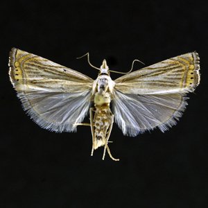
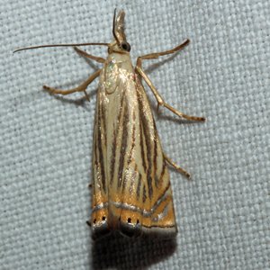
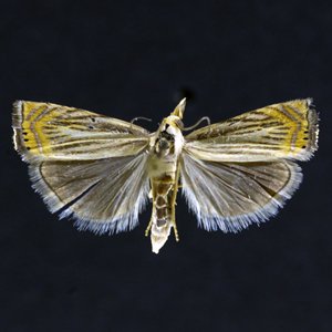
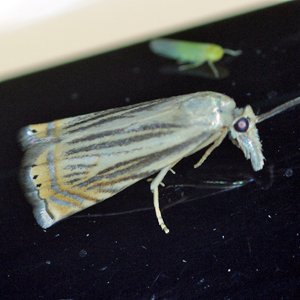
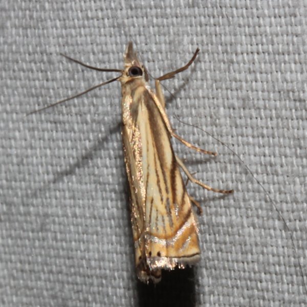
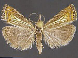
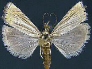
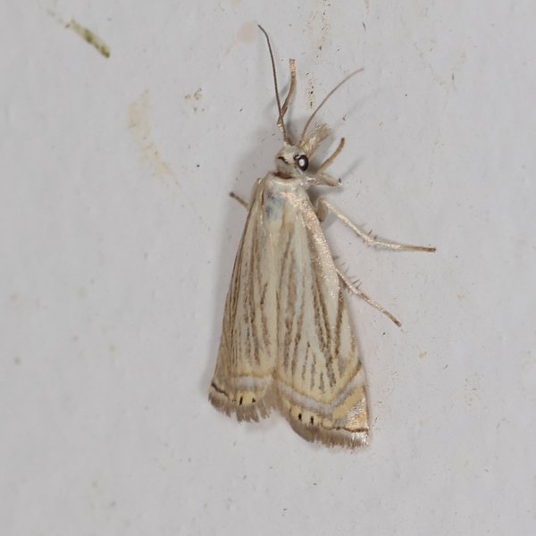
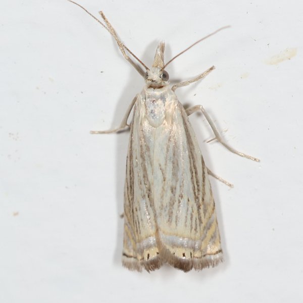
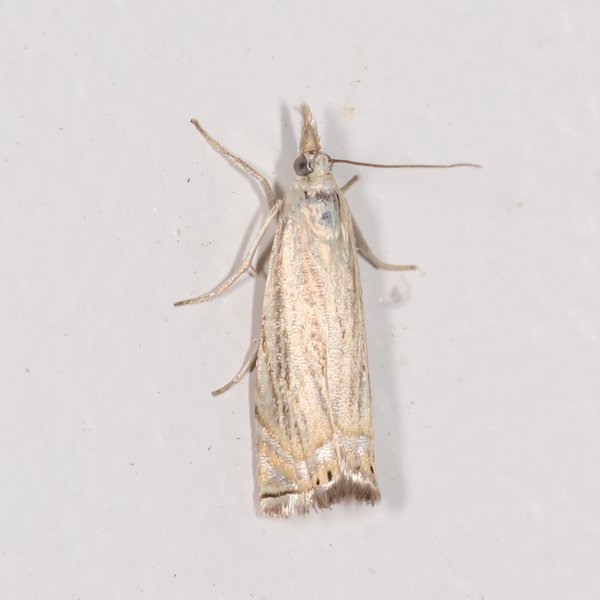
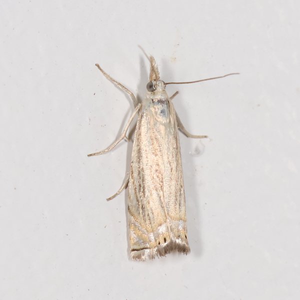
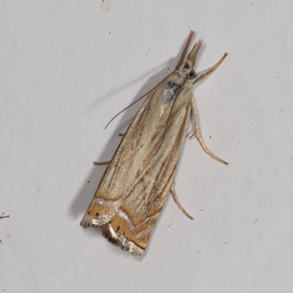
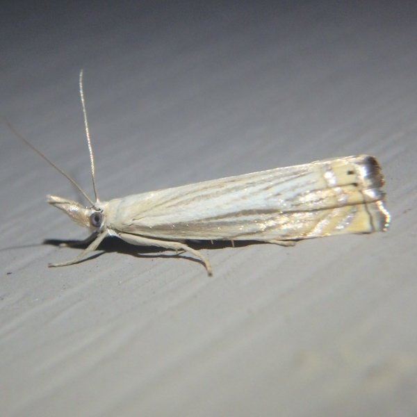
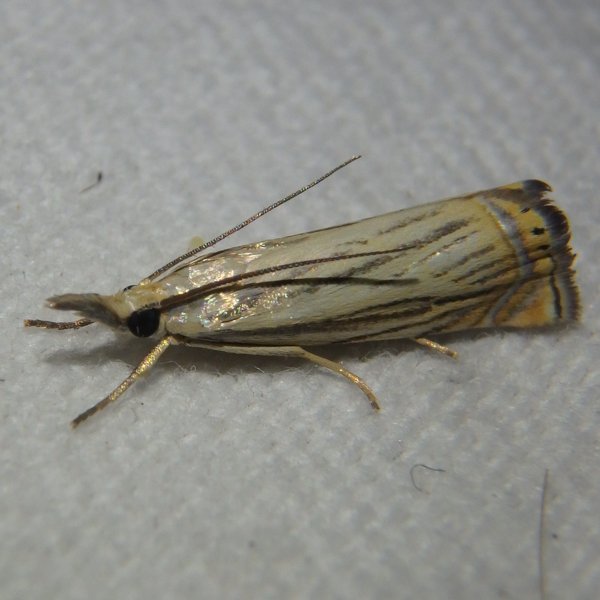
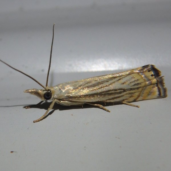
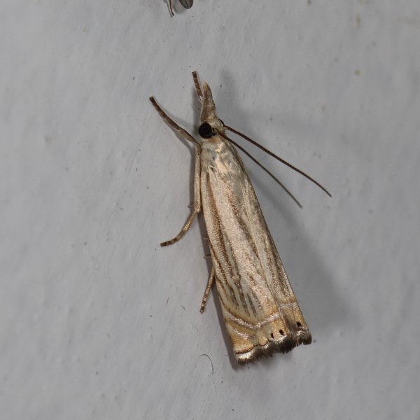
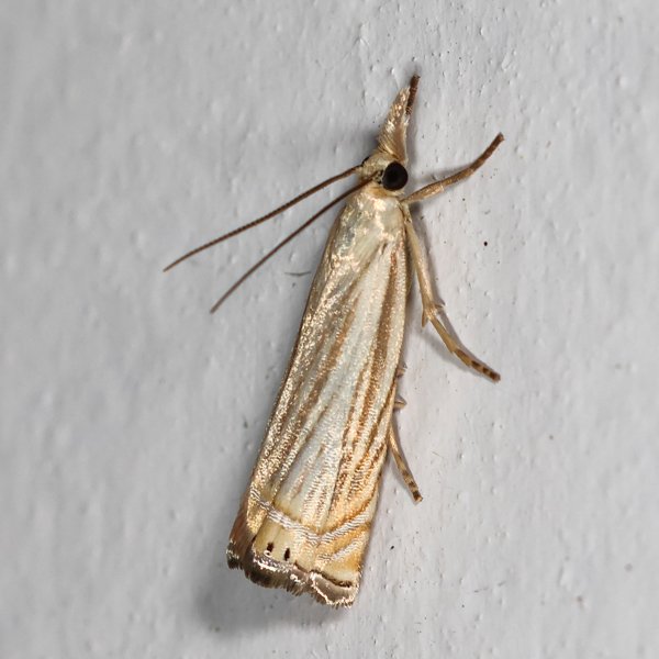
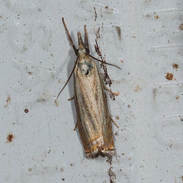
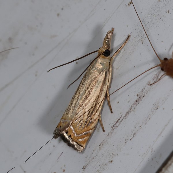
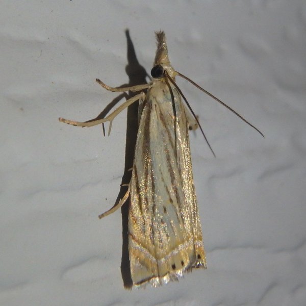
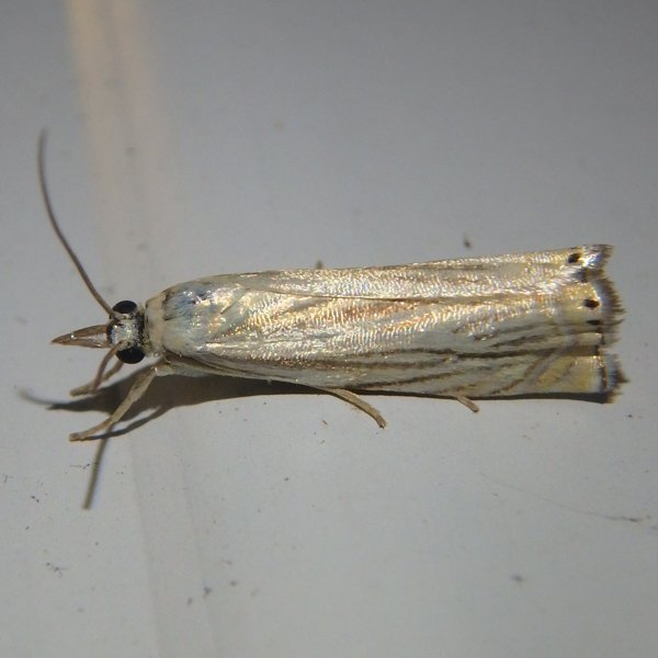
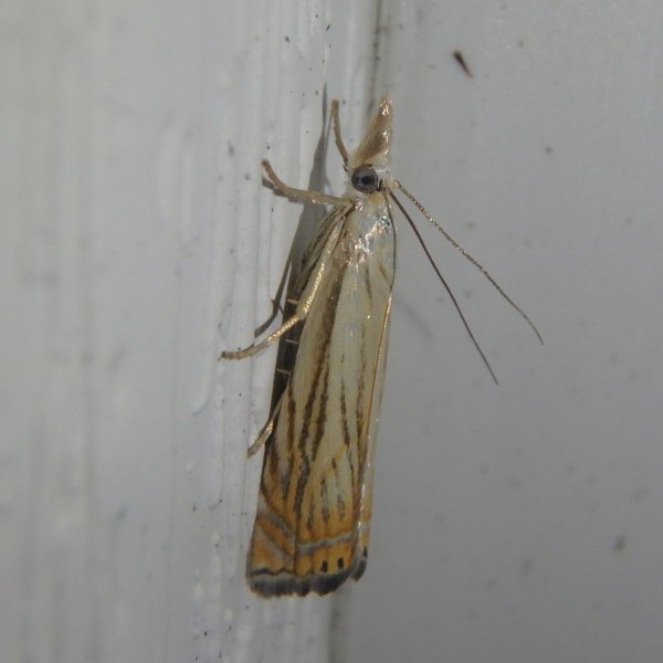
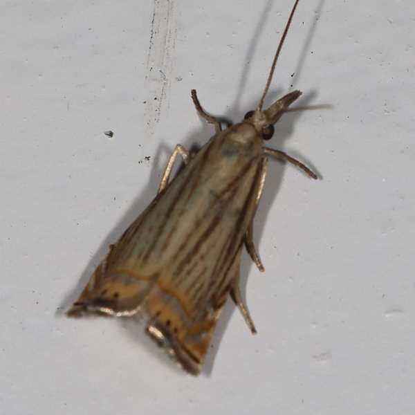
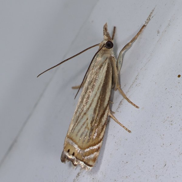
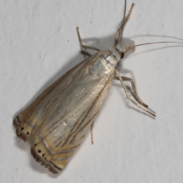
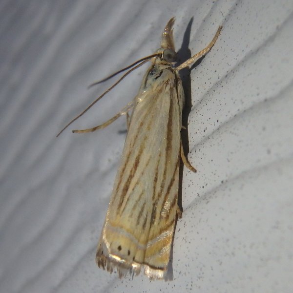
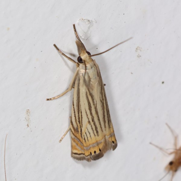
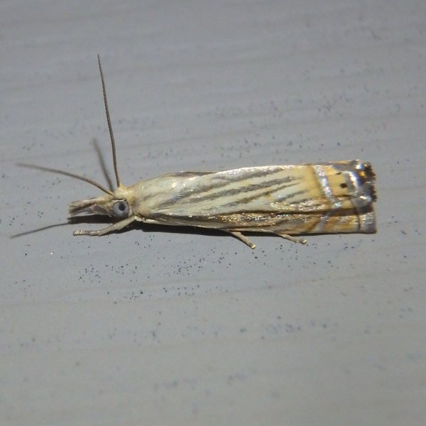
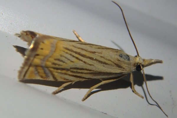
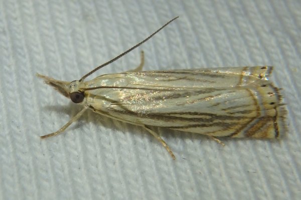
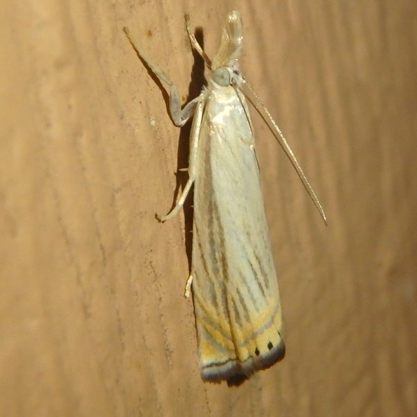
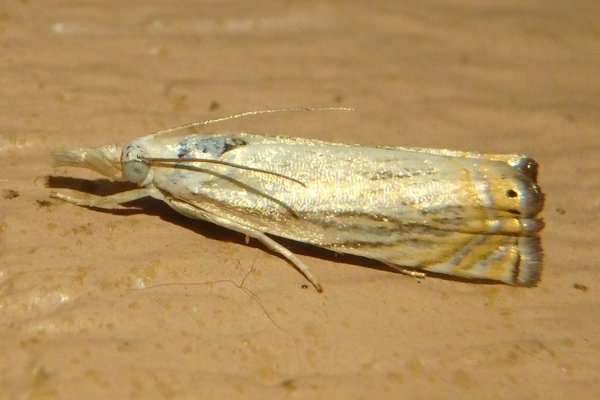
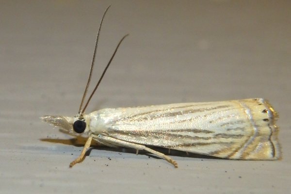
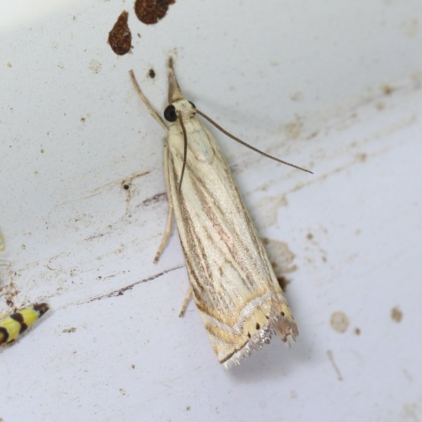
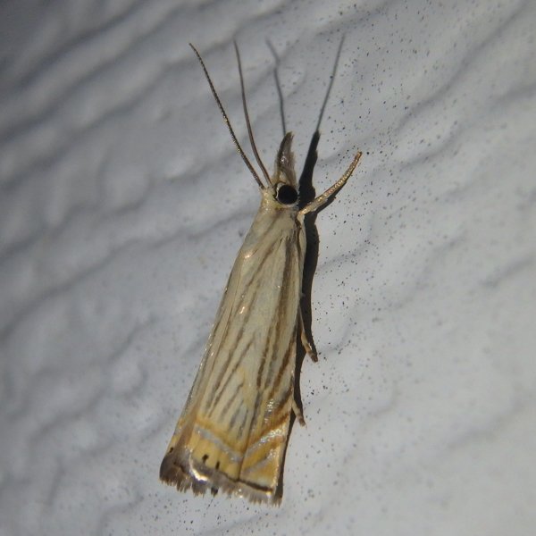
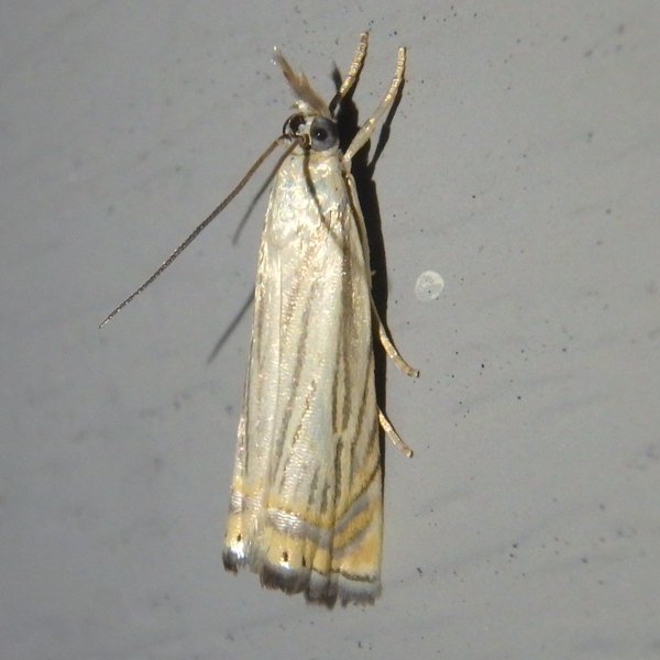
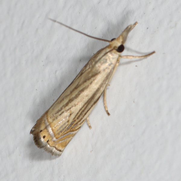
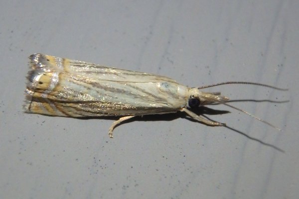
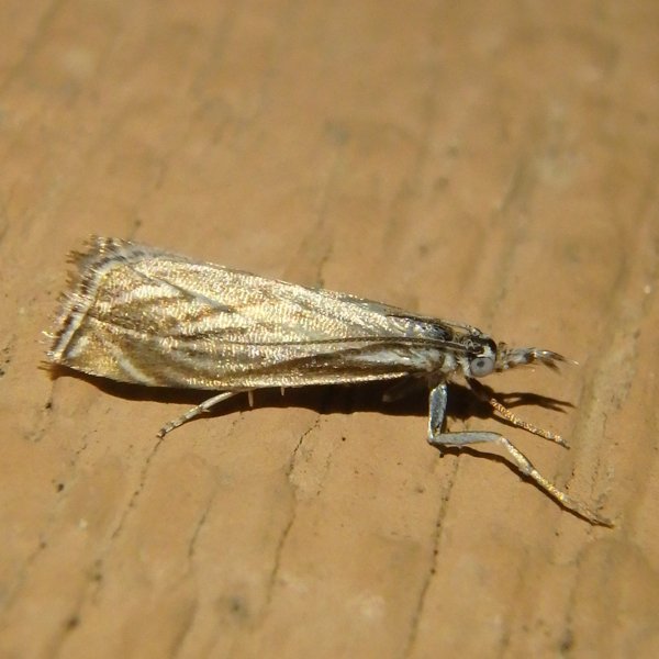
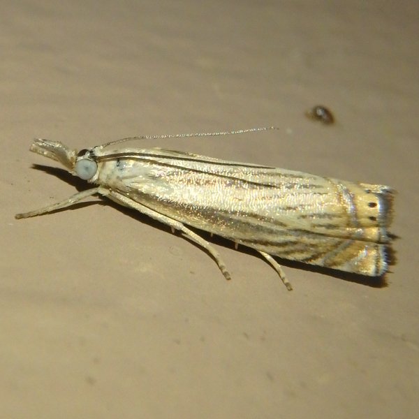
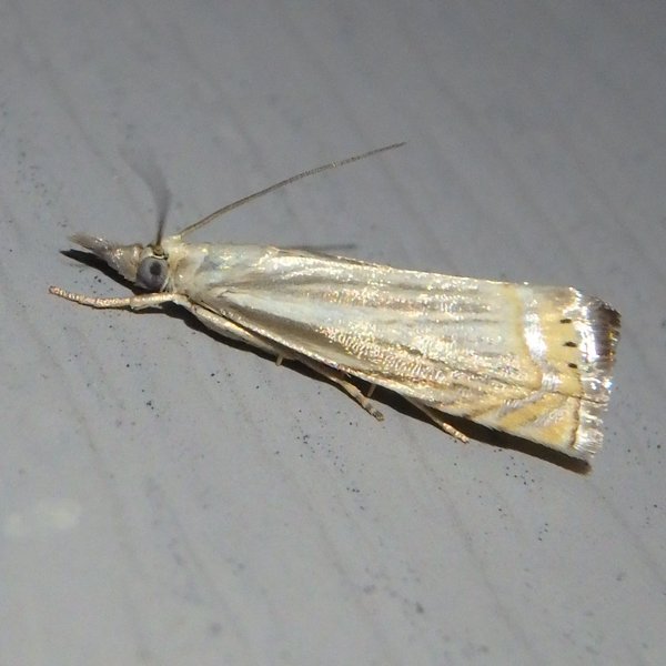
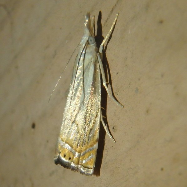
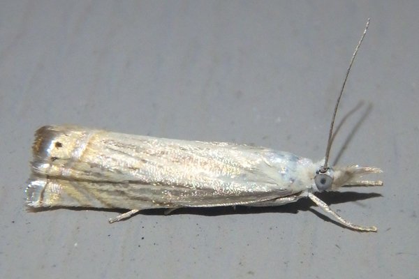
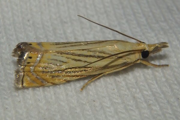
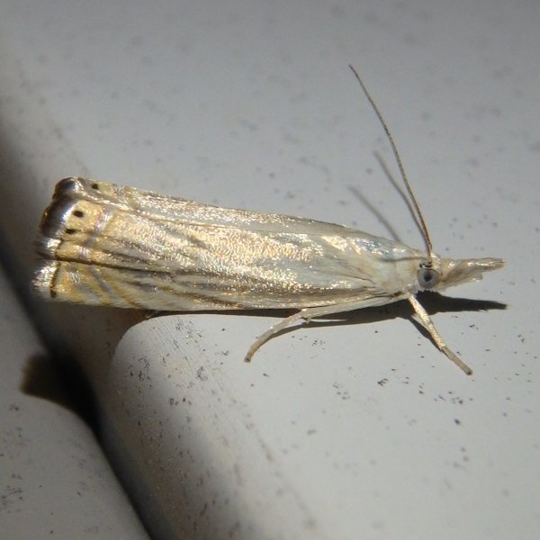
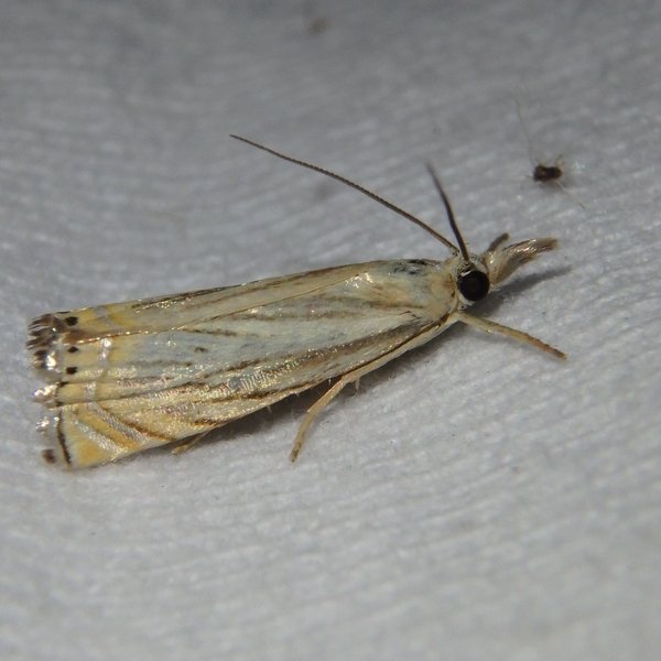
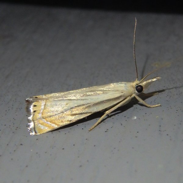
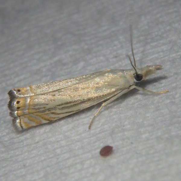
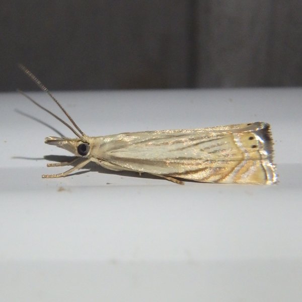
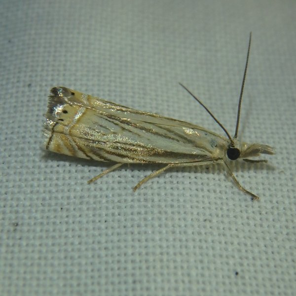
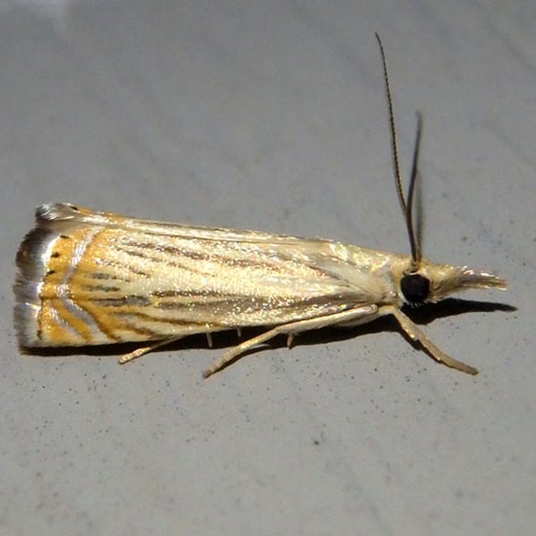
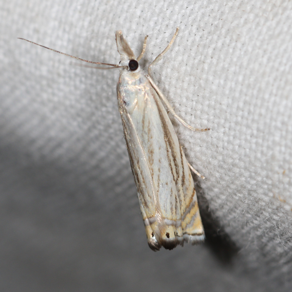
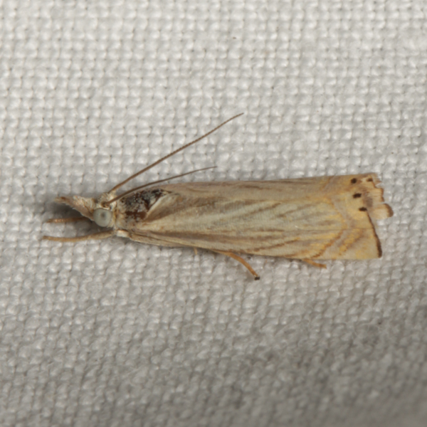
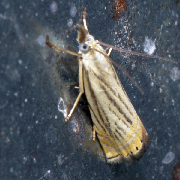
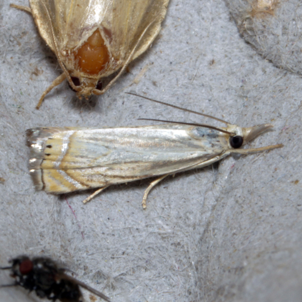
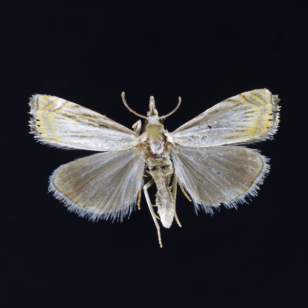
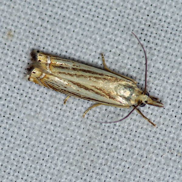
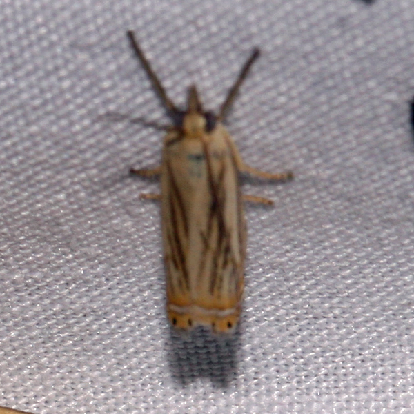
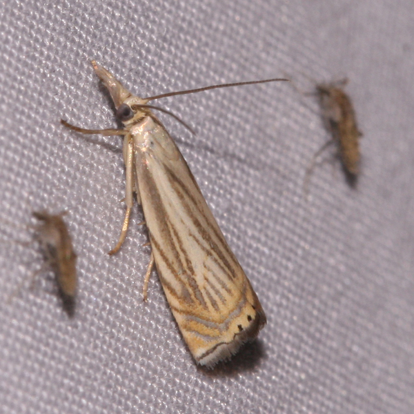
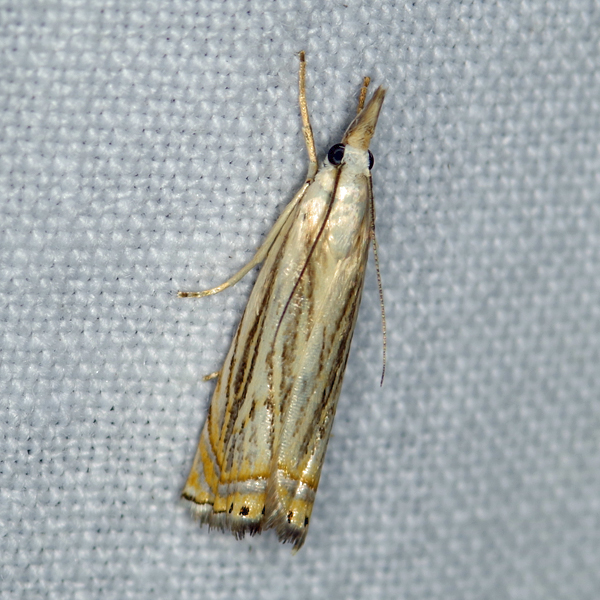
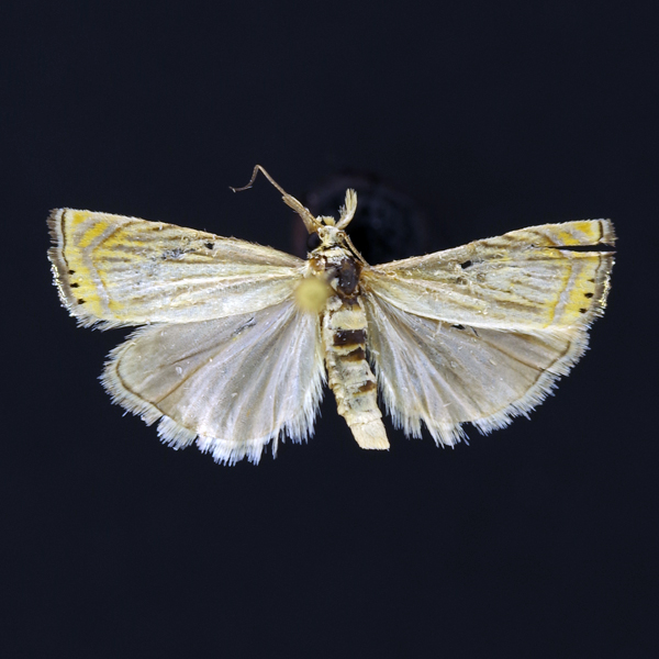
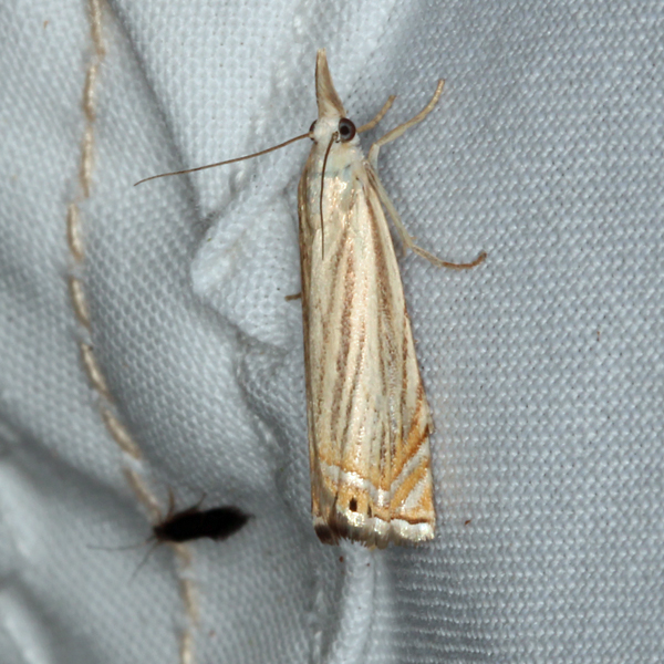
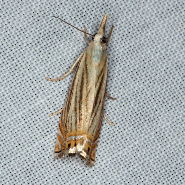
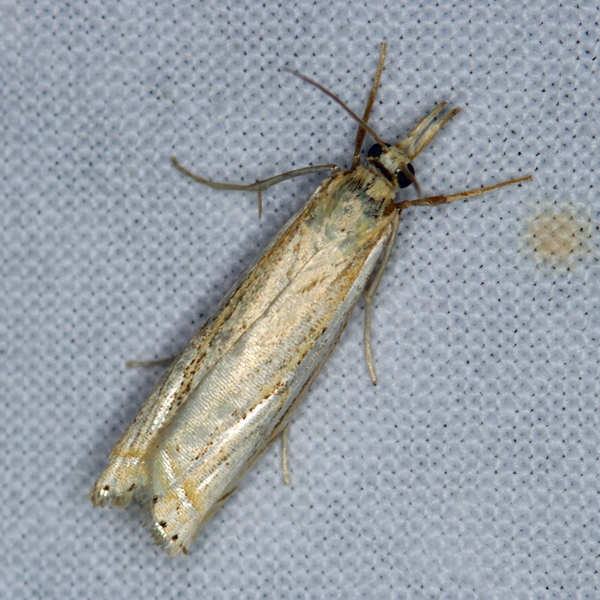
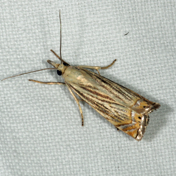
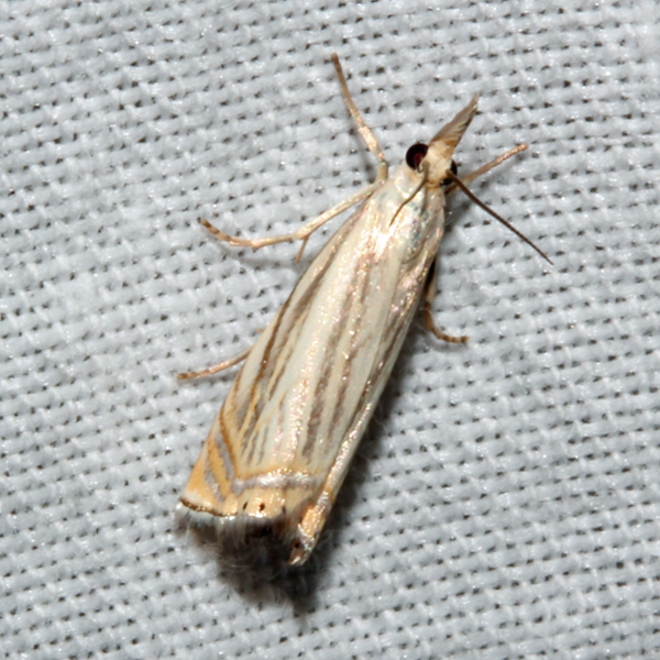
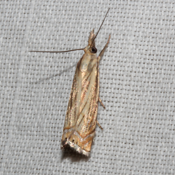
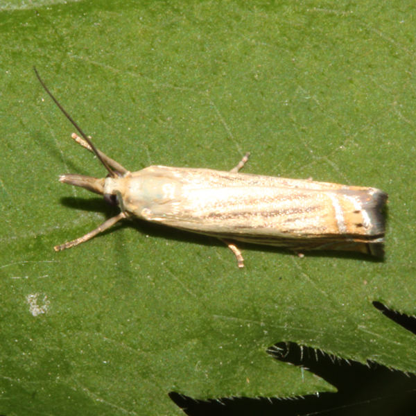
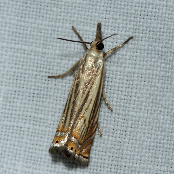
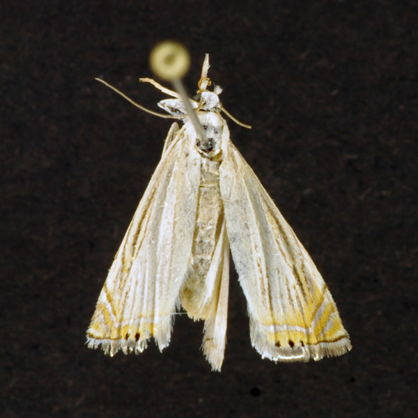
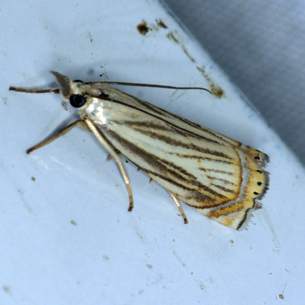
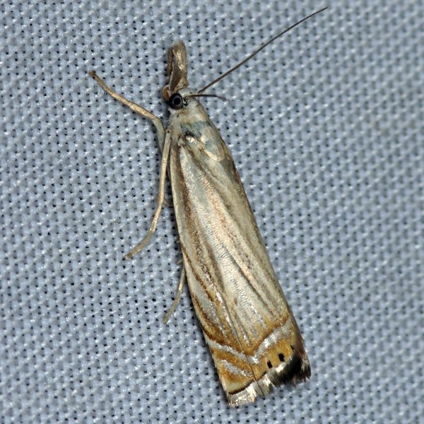
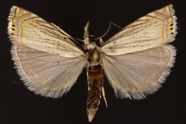
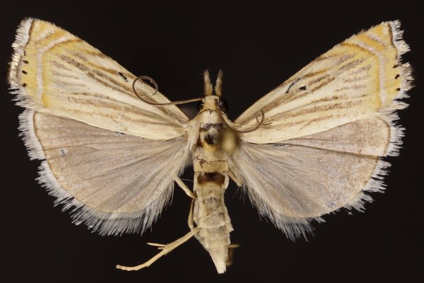
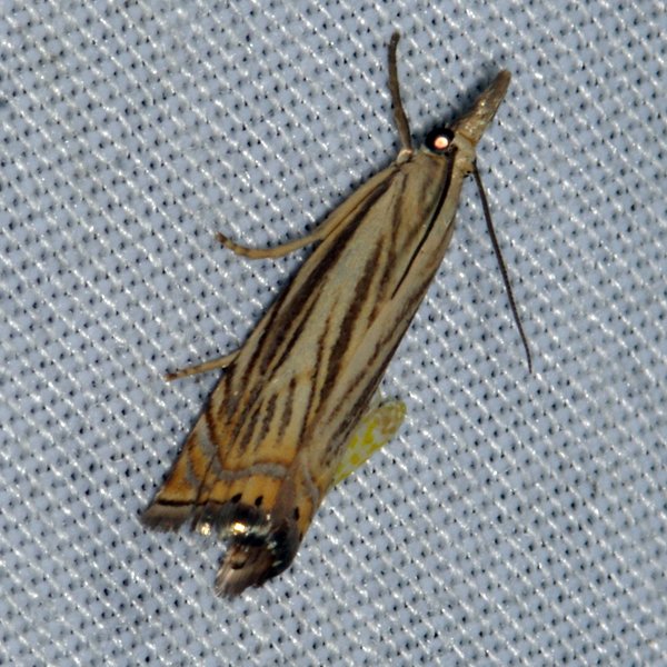
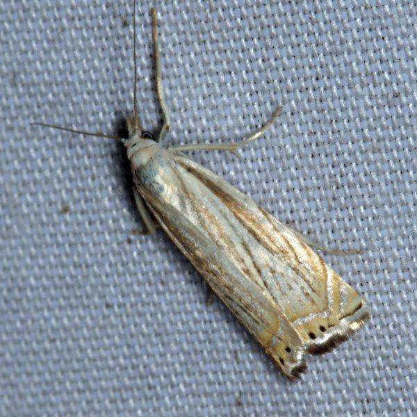
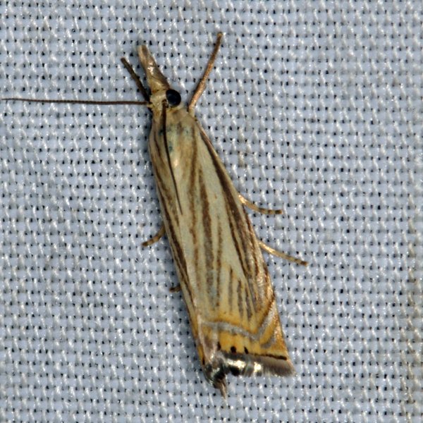
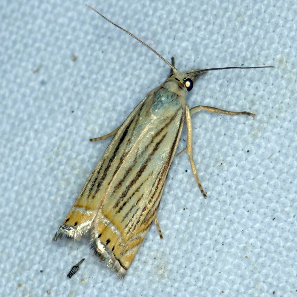
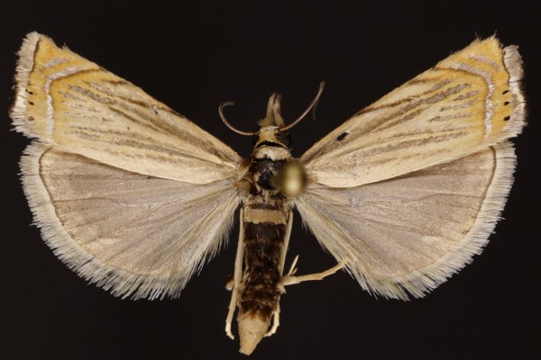
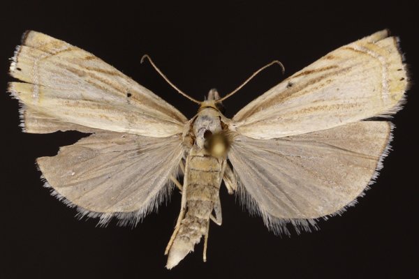
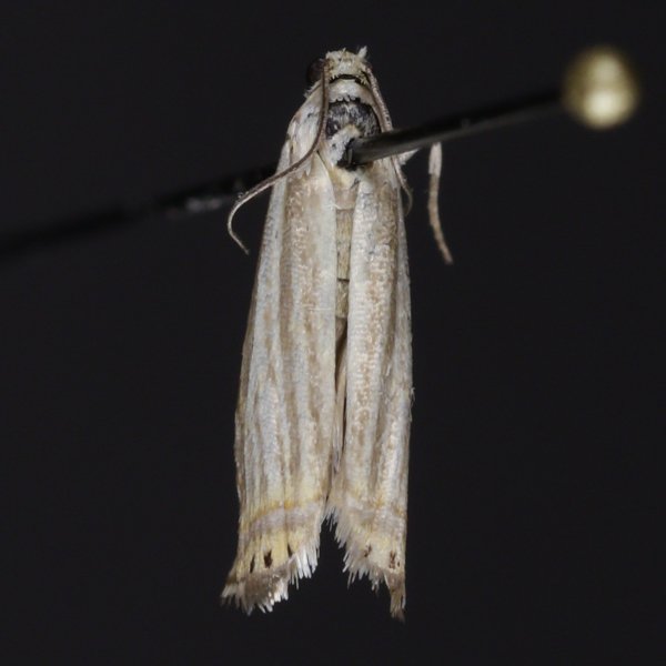
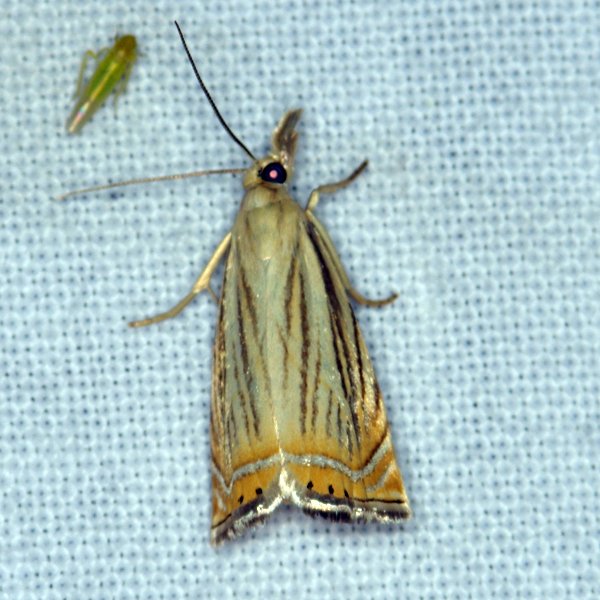
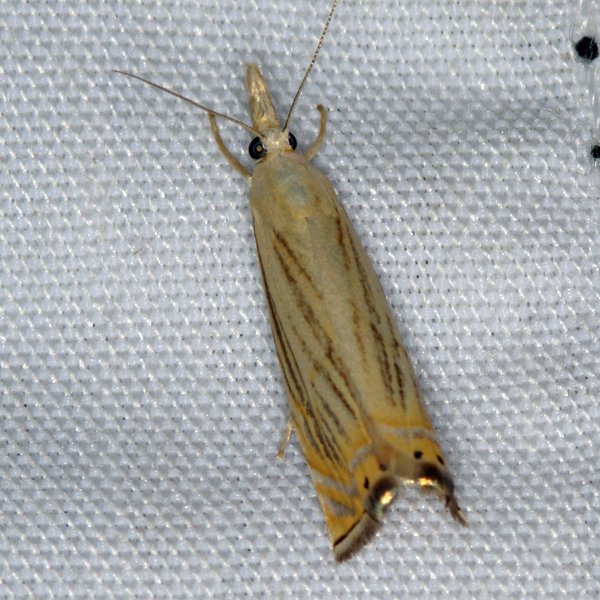
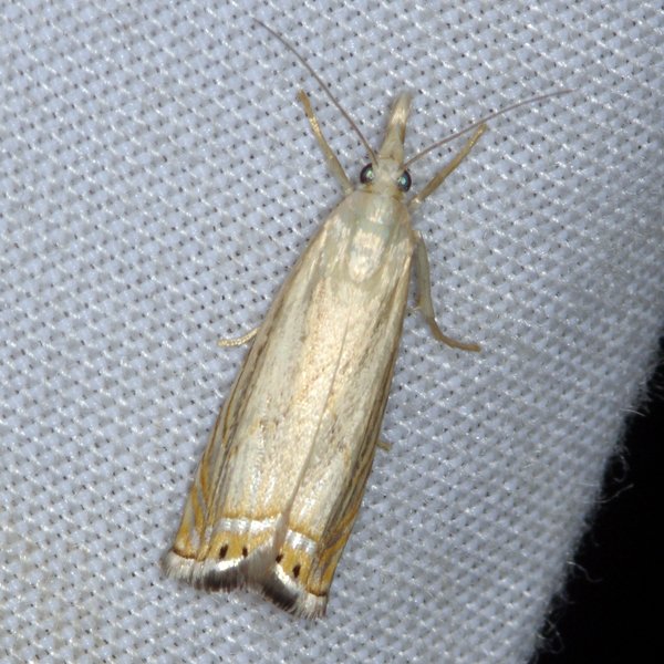
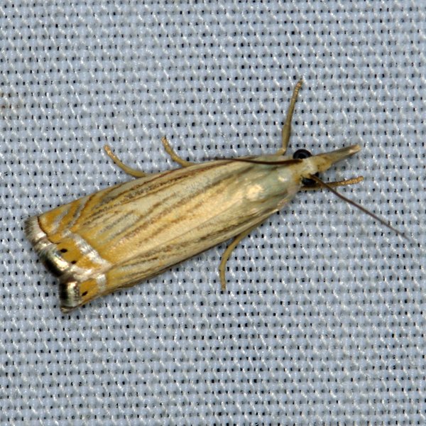
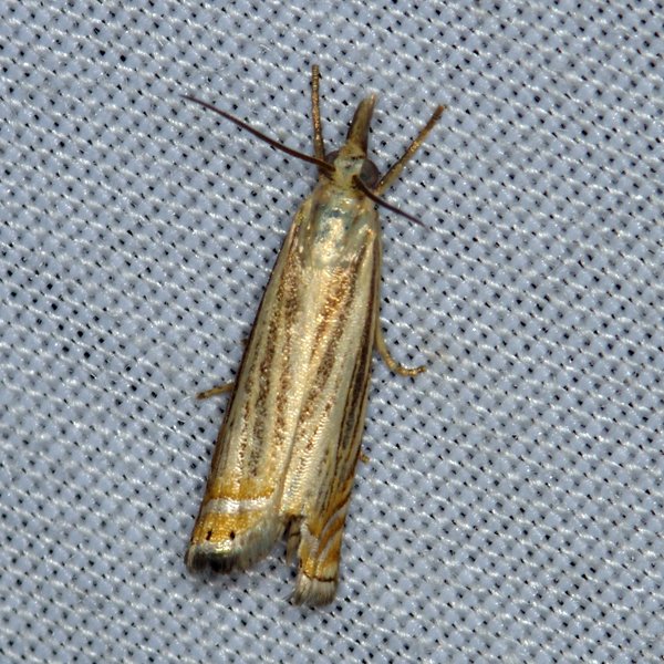
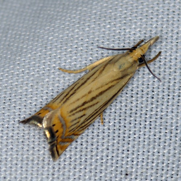
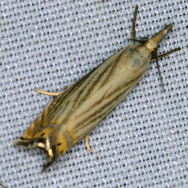
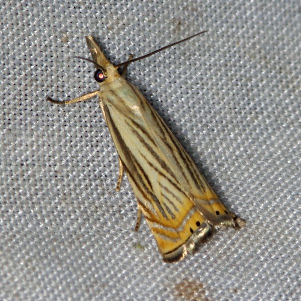
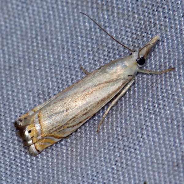
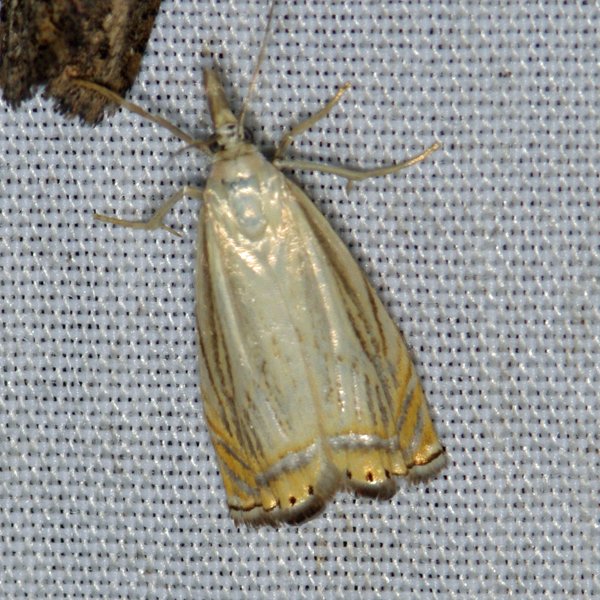
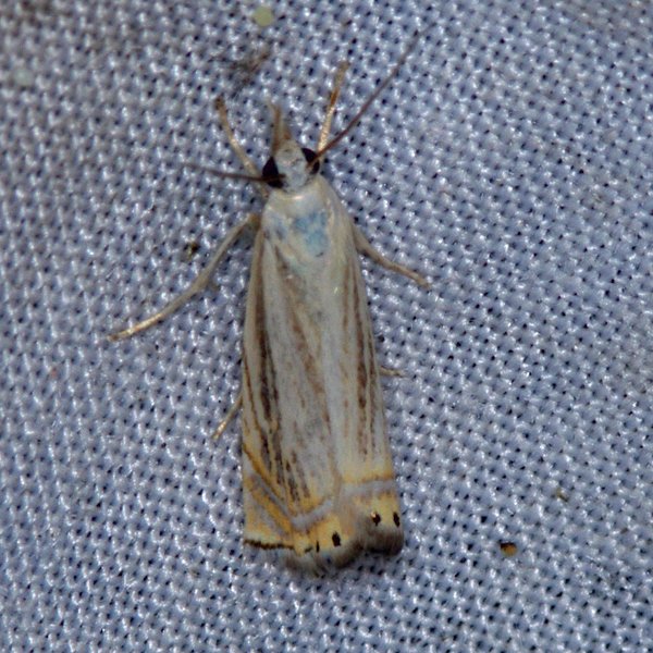
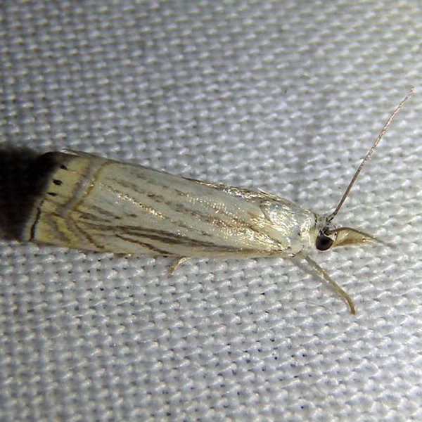
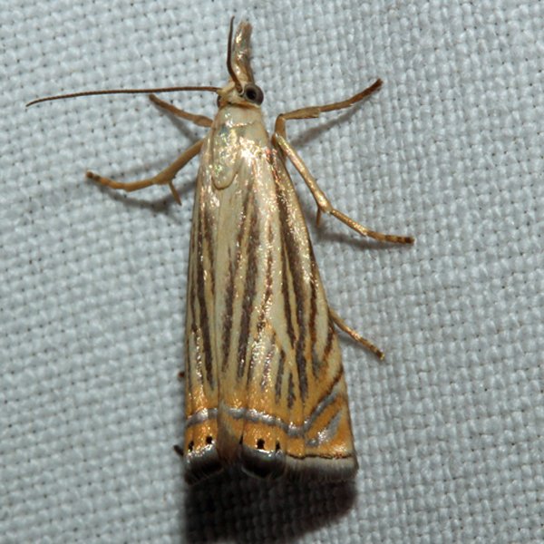
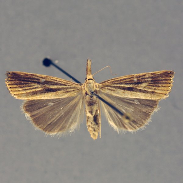
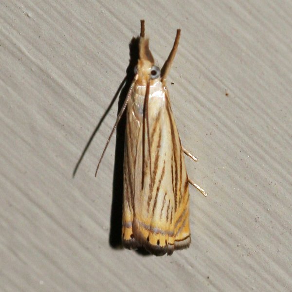
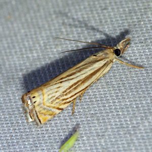
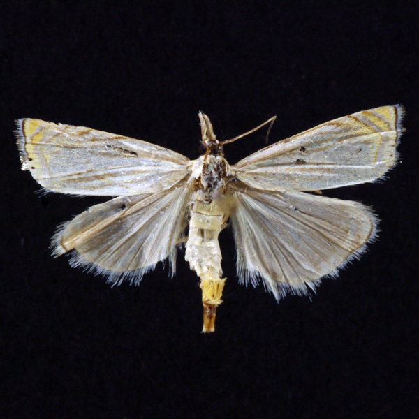
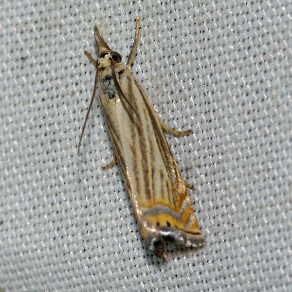
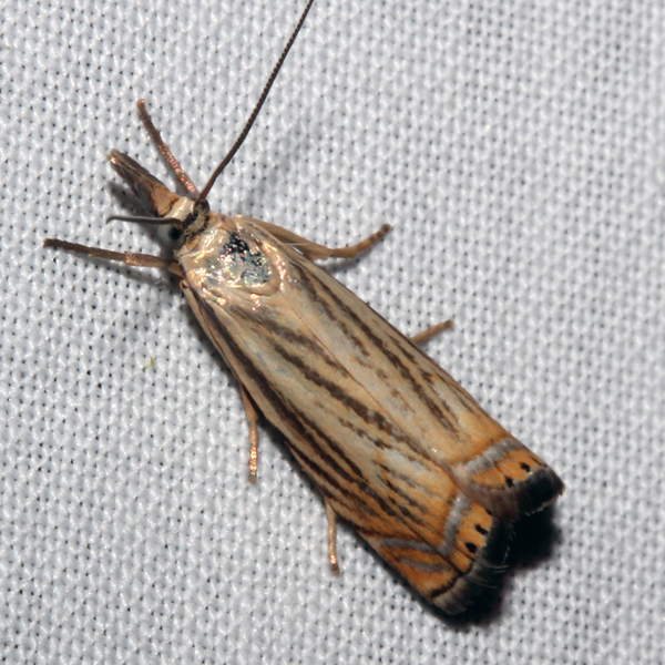
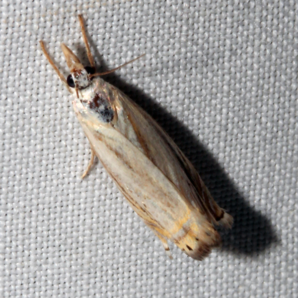
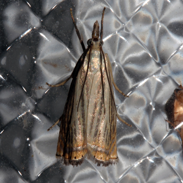
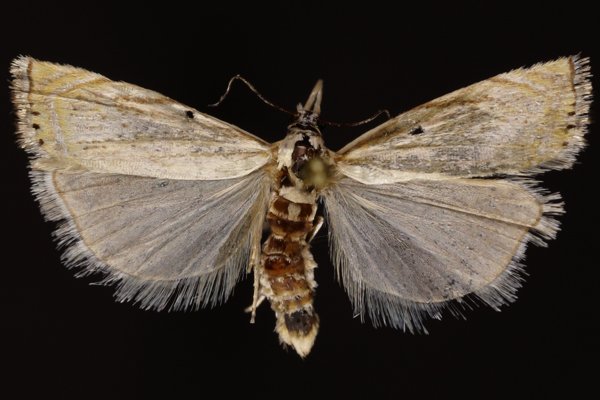
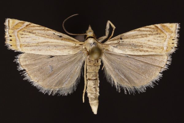
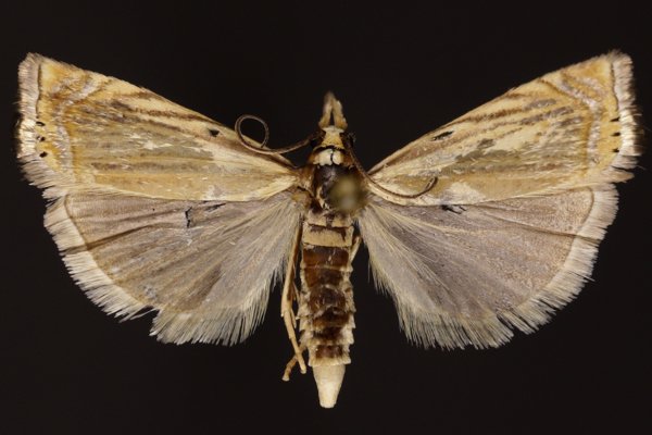
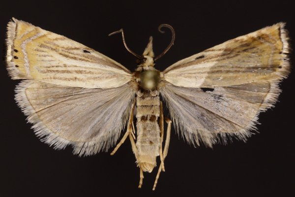
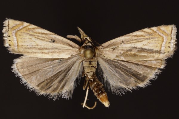
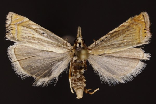
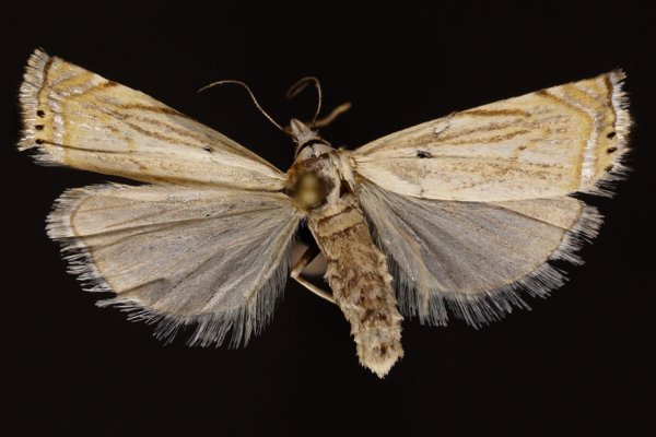
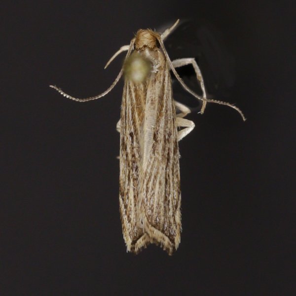
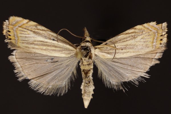
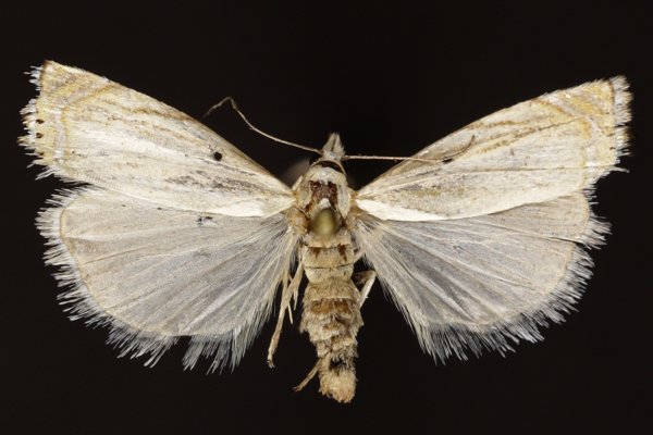
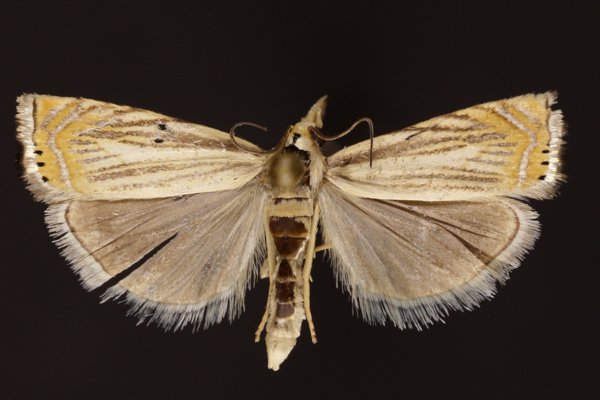
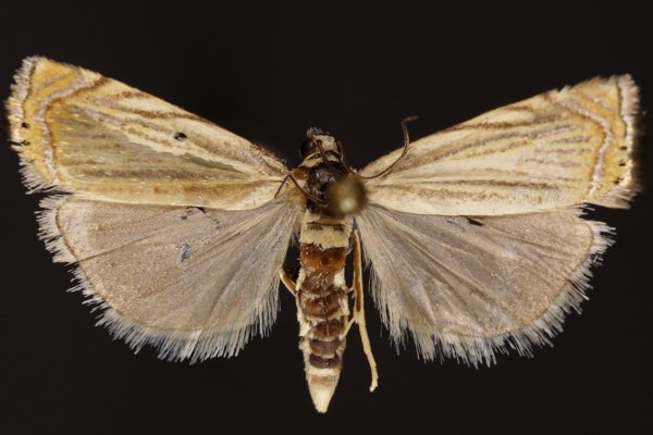
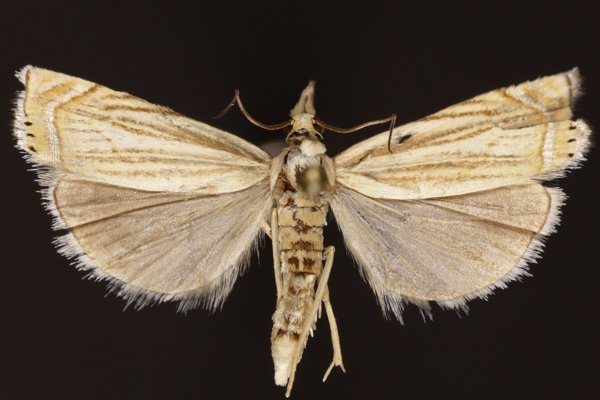
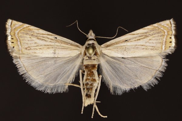
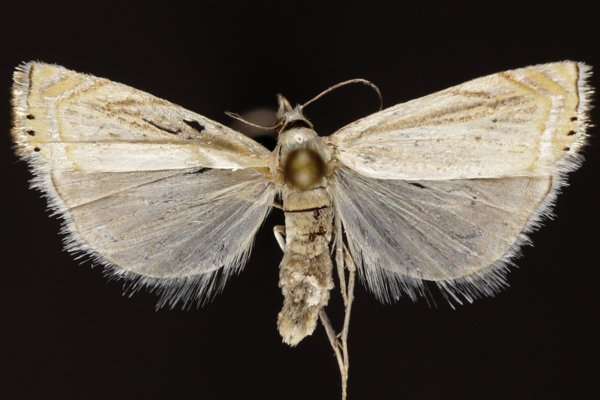
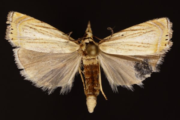
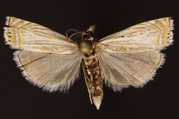
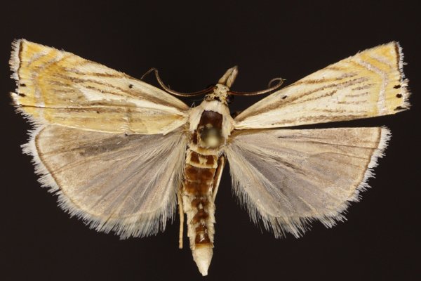
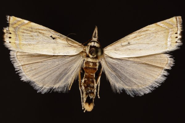
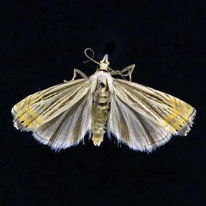
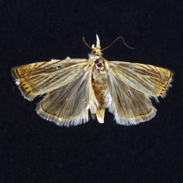
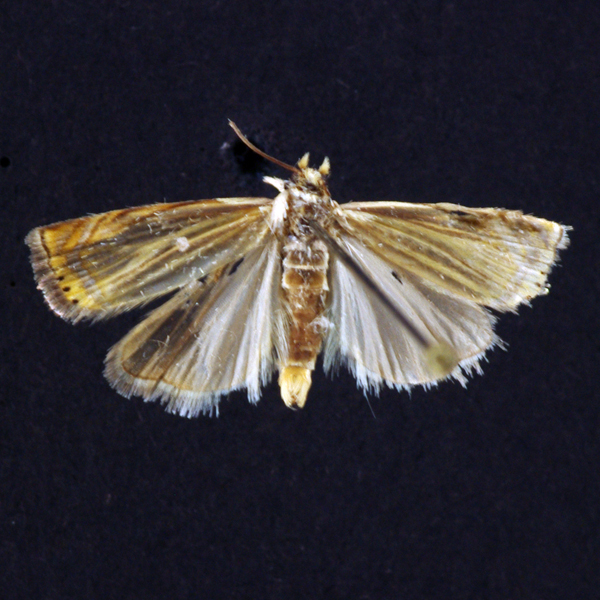
Topiary Grass-veneer (Chrysoteuchia topiarius), (Zeller, 1866) - 5391.000000 - 80a1548
Identification:
Wing Span: 20mm
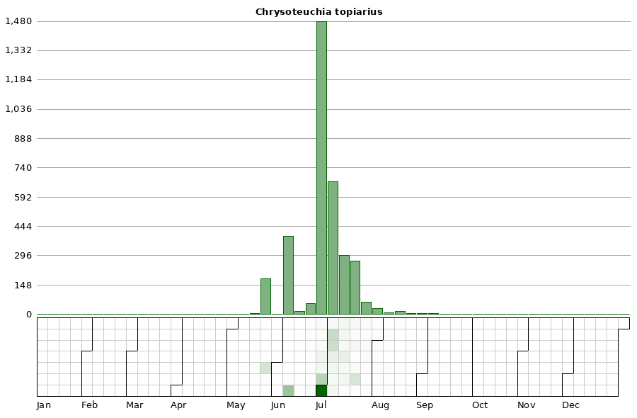
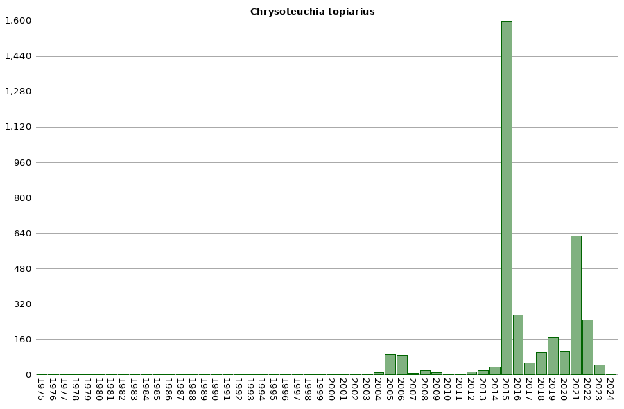
Life History:
Caterpillar Hosts:
Adult Food:
Habitat:
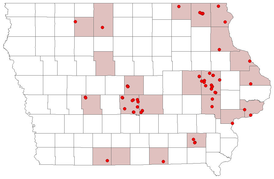
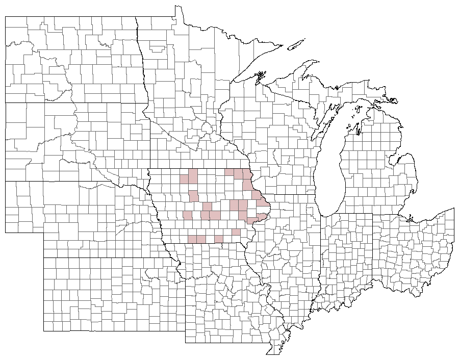
Range:
Conservation:
NCGR:
Management Needs:
Photos


Records
| Record # | Date | Locale | State | Lat/Lon | Collected By | Count |
|---|---|---|---|---|---|---|
 339814 339814
|
2023-08-17 | Big Sand Mound Prairie Preserve, Muscatine County | Iowa | 41.34031372 -91.0810559 | Jim Durbin | 1 |
 339928 339928
|
2023-08-17 | Big Sand Mound Prairie Preserve, Muscatine County | Iowa | 41.34031372 -91.0810559 | Jim Durbin | 1 |
 339932 339932
|
2023-08-17 | Big Sand Mound Prairie Preserve, Muscatine County | Iowa | 41.34031372 -91.0810559 | Jim Durbin | 1 |
 339934 339934
|
2023-08-17 | Big Sand Mound Prairie Preserve, Muscatine County | Iowa | 41.34031372 -91.0810559 | Jim Durbin | 1 |
 339205 339205
|
2023-08-02 | Wanatee County Park | Iowa | 42.00997111 -91.5665254 | Jim Durbin | 1 |
 339224 339224
|
2023-08-02 | Wanatee County Park | Iowa | 42.00997111 -91.5665254 | Jim Durbin | 1 |
 338735 338735
|
2023-07-25 | Pinicon Ridge Park | Iowa | 42.2108105 -91.54420598 | Jim Durbin | 1 |
 345123 345123
|
2023-07-23 | Johnson County, Iowa | Iowa | Location Protected | Mark Brown | 1 |
 345149 345149
|
2023-07-21 | Johnson County, Iowa | Iowa | Location Protected | Mark Brown | 1 |
 338286 338286
|
2023-07-20 | Palisades Kepler State Park | Iowa | 41.90828891 -91.50245954 | Jim Durbin | 1 |
 338287 338287
|
2023-07-20 | Palisades Kepler State Park | Iowa | 41.90828891 -91.50245954 | Jim Durbin | 1 |
 338302 338302
|
2023-07-20 | Palisades Kepler State Park | Iowa | 41.90828891 -91.50245954 | Jim Durbin | 1 |
 338335 338335
|
2023-07-20 | Palisades Kepler State Park | Iowa | 41.90828891 -91.50245954 | Jim Durbin | 1 |
 345175 345175
|
2023-07-19 | Johnson County, Iowa | Iowa | Location Protected | Mark Brown | 1 |
 338084 338084
|
2023-07-18 | Big Sand Mound Prairie Preserve, Muscatine County | Iowa | 41.34026787 -91.08103262 | Jim Durbin | 1 |
 338090 338090
|
2023-07-18 | Big Sand Mound Prairie Preserve, Muscatine County | Iowa | 41.34026787 -91.08103262 | Jim Durbin | 1 |
 338110 338110
|
2023-07-18 | Big Sand Mound Prairie Preserve, Muscatine County | Iowa | 41.34026787 -91.08103262 | Jim Durbin | 1 |
 338155 338155
|
2023-07-18 | Big Sand Mound Prairie Preserve, Muscatine County | Iowa | 41.34026787 -91.08103262 | Jim Durbin | 1 |
 337854 337854
|
2023-07-16 | Matsell Bridge Natural Area | Iowa | 42.13217249 -91.38522877 | Jim Durbin | 1 |
 337953 337953
|
2023-07-16 | Matsell Bridge Natural Area | Iowa | 42.13217249 -91.38522877 | Jim Durbin | 1 |
 337994 337994
|
2023-07-16 | Matsell Bridge Natural Area | Iowa | 42.13217249 -91.38522877 | Jim Durbin | 1 |
 338005 338005
|
2023-07-16 | Matsell Bridge Natural Area | Iowa | 42.13217249 -91.38522877 | Jim Durbin | 1 |
 345205 345205
|
2023-07-16 | Johnson County, Iowa | Iowa | Location Protected | Mark Brown | 1 |
 343501 343501
|
2023-07-14 | Johnson County, Iowa | Iowa | Location Protected | Mark Brown | 1 |
 343524 343524
|
2023-07-12 | Johnson County, Iowa | Iowa | Location Protected | Mark Brown | 1 |
 337470 337470
|
2023-07-11 | Wildcat Bluff Recreational Area | Iowa | 42.19420145 -91.8821574 | Jim Durbin | 1 |
 337477 337477
|
2023-07-11 | Wildcat Bluff Recreational Area | Iowa | 42.19420145 -91.8821574 | Jim Durbin | 1 |
 337512 337512
|
2023-07-11 | Wildcat Bluff Recreational Area | Iowa | 42.19420145 -91.8821574 | Jim Durbin | 1 |
 343550 343550
|
2023-07-09 | Johnson County, Iowa | Iowa | Location Protected | Mark Brown | 1 |
 337239 337239
|
2023-07-08 | Palisades Kepler State Park | Iowa | 41.90829802 -91.50242489 | Jim Durbin | 1 |
 337254 337254
|
2023-07-08 | Palisades Kepler State Park | Iowa | 41.90829802 -91.50242489 | Jim Durbin | 1 |
 336853 336853
|
2023-07-06 | Wildcat Bluff Recreational Area | Iowa | 42.19331874 -91.88041838 | Jim Durbin | 1 |
 343363 343363
|
2023-07-04 | Johnson County, Iowa | Iowa | Location Protected | Mark Brown | 1 |
 336607 336607
|
2023-07-03 | Hitaga Sand Ridge Prairie Preserve | Iowa | 42.250717995 -91.632138603333 | Jim Durbin | 1 |
 336621 336621
|
2023-07-03 | Hitaga Sand Ridge Prairie Preserve | Iowa | 42.250717995 -91.632138603333 | Jim Durbin | 1 |
 343353 343353
|
2023-07-03 | Johnson County, Iowa | Iowa | Location Protected | Mark Brown | 1 |
 336773 336773
|
2023-07-02 | 1460 Douglas Ct, Marion | Iowa | 42.040098668333 -91.590915611667 | Jim Durbin | 1 |
 336137 336137
|
2023-06-29 | Indian Creek Nature Center | Iowa | 41.96608977 -91.58982624 | Jim Durbin | 1 |
 336195 336195
|
2023-06-29 | Indian Creek Nature Center | Iowa | 41.96608977 -91.58982624 | Jim Durbin | 1 |
 335907 335907
|
2023-06-25 | Yellow Banks Park | Iowa | 41.548183631667 -93.473158521667 | Jim Durbin | 1 |
 335278 335278
|
2023-06-17 | Wanatee County Park | Iowa | 42.010114365 -91.566550498333 | Jim Durbin | 1 |
| 321508 | 2022-09-05 | Ames, Paul | Iowa | 42.011954 -93.615226 | Paul Martsching | 1 |
| 321484 | 2022-08-26 | Ames, Paul | Iowa | 42.011954 -93.615226 | Paul Martsching | 1 |
 332402 332402
|
2022-08-07 | Johnson County, Iowa | Iowa | Location Protected | Mark Brown | 1 |
 332433 332433
|
2022-08-04 | Johnson County, Iowa | Iowa | Location Protected | Mark Brown | 1 |
| 321437 | 2022-08-03 | Ames, Paul | Iowa | 42.011954 -93.615226 | Paul Martsching | 1 |
 316093 316093
|
2022-08-02 | Willow Creek/Kiwanis Park | Iowa | 41.647924 -91.569677 | Peter Hansen | 1 |
 312663 312663
|
2022-07-26 | Hitaga Sand Ridge Prairie Preserve | Iowa | 42.25103779 -91.63215575 | Jim Durbin | 1 |
 316092 316092
|
2022-07-25 | Willow Creek/Kiwanis Park | Iowa | 41.647924 -91.569677 | Peter Hansen | 1 |
| 321426 | 2022-07-25 | Ames, Paul | Iowa | 42.011954 -93.615226 | Paul Martsching | 2 |
 316091 316091
|
2022-07-22 | Willow Creek/Kiwanis Park | Iowa | 41.647924 -91.569677 | Peter Hansen | 1 |
 320696 320696
|
2022-07-22 | MacBride Nature Recreation Area | Iowa | 41.7869394 -91.5684859 | Mark Brown | 1 |
 320723 320723
|
2022-07-21 | MacBride Nature Recreation Area | Iowa | 41.7869394 -91.5684859 | Mark Brown | 1 |
| 321418 | 2022-07-21 | Ames, Paul | Iowa | 42.011954 -93.615226 | Paul Martsching | 150 |
 320742 320742
|
2022-07-20 | Johnson County, Iowa | Iowa | Location Protected | Mark Brown | 1 |
 312130 312130
|
2022-07-18 | Wanatee County Park | Iowa | 42.01008617 -91.56657306 | Jim Durbin | 1 |
 312157 312157
|
2022-07-18 | Wanatee County Park | Iowa | 42.01008617 -91.56657306 | Jim Durbin | 1 |
| 321399 | 2022-07-18 | Ames, Paul | Iowa | 42.011954 -93.615226 | Paul Martsching | 12 |
 320840 320840
|
2022-07-17 | Johnson County, Iowa | Iowa | Location Protected | Mark Brown | 1 |
 320395 320395
|
2022-07-13 | Johnson County, Iowa | Iowa | Location Protected | Mark Brown | 1 |
| 321394 | 2022-07-13 | Ames, Paul | Iowa | 42.011954 -93.615226 | Paul Martsching | 8 |
 311841 311841
|
2022-07-12 | Matsell Bridge Natural Area | Iowa | 42.13222612 -91.38533046 | Jim Durbin | 1 |
 311844 311844
|
2022-07-12 | Matsell Bridge Natural Area | Iowa | 42.13222612 -91.38533046 | Jim Durbin | 1 |
 311870 311870
|
2022-07-12 | Matsell Bridge Natural Area | Iowa | 42.13222612 -91.38533046 | Jim Durbin | 1 |
 311994 311994
|
2022-07-12 | Matsell Bridge Natural Area | Iowa | 42.13222612 -91.38533046 | Jim Durbin | 1 |
 320419 320419
|
2022-07-12 | Johnson County, Iowa | Iowa | Location Protected | Mark Brown | 1 |
 319541 319541
|
2022-07-07 | MacBride Nature Recreation Area | Iowa | 41.78692473 -91.56852435 | Mark Brown | 1 |
 319543 319543
|
2022-07-07 | MacBride Nature Recreation Area | Iowa | 41.78692473 -91.56852435 | Mark Brown | 1 |
 319567 319567
|
2022-07-06 | Johnson County, Iowa | Iowa | Location Protected | Mark Brown | 1 |
 316327 316327
|
2022-07-03 | MacBride Nature Recreation Area | Iowa | 41.78686664 -91.56856993 | Mark Brown | 1 |
| 321385 | 2022-07-03 | Ames, Paul | Iowa | 42.011954 -93.615226 | Paul Martsching | 30 |
 311375 311375
|
2022-07-02 | Wanatee County Park | Iowa | 42.01013441 -91.56662262 | Jim Durbin | 1 |
 311377 311377
|
2022-07-02 | Wanatee County Park | Iowa | 42.01013441 -91.56662262 | Jim Durbin | 1 |
 311418 311418
|
2022-07-02 | Wanatee County Park | Iowa | 42.01013441 -91.56662262 | Jim Durbin | 1 |
 311516 311516
|
2022-07-02 | Wanatee County Park | Iowa | 42.01013441 -91.56662262 | Jim Durbin | 1 |
 311528 311528
|
2022-07-02 | Wanatee County Park | Iowa | 42.01013441 -91.56662262 | Jim Durbin | 1 |
 316405 316405
|
2022-07-02 | Johnson County, Iowa | Iowa | Location Protected | Mark Brown | 1 |
 316410 316410
|
2022-07-02 | Johnson County, Iowa | Iowa | Location Protected | Mark Brown | 1 |
 315569 315569
|
2022-06-29 | Johnson County, Iowa | Iowa | Location Protected | Mark Brown | 1 |
| 321374 | 2022-06-29 | Ames, Paul | Iowa | 42.011954 -93.615226 | Paul Martsching | 7 |
 311099 311099
|
2022-06-28 | Hitaga Sand Ridge Prairie Preserve | Iowa | 42.2510735 -91.63217209 | Jim Durbin | 1 |
 311115 311115
|
2022-06-28 | Hitaga Sand Ridge Prairie Preserve | Iowa | 42.2510735 -91.63217209 | Jim Durbin | 1 |
 311121 311121
|
2022-06-28 | Hitaga Sand Ridge Prairie Preserve | Iowa | 42.2510735 -91.63217209 | Jim Durbin | 1 |
 311143 311143
|
2022-06-28 | Hitaga Sand Ridge Prairie Preserve | Iowa | 42.2510735 -91.63217209 | Jim Durbin | 1 |
 315624 315624
|
2022-06-22 | Johnson County, Iowa | Iowa | Location Protected | Mark Brown | 1 |
| 298660 | 2021-07-26 | Ames, Paul | Iowa | 42.011732 -93.615039 | Paul Martsching | 1 |
 295238 295238
|
2021-07-22 | Johnson County, Iowa | Iowa | Location Protected | Mark Brown | 1 |
 307239 307239
|
2021-07-21 | Near Fairfield | Iowa | 41.05061219 -92.02396433 | Moni Hayne | 1 |
 295278 295278
|
2021-07-18 | Johnson County, Iowa | Iowa | Location Protected | Mark Brown | 1 |
 295307 295307
|
2021-07-16 | Johnson County, Iowa | Iowa | Location Protected | Mark Brown | 1 |
| 298599 | 2021-07-14 | Ames, Paul | Iowa | 42.011732 -93.615039 | Paul Martsching | 10 |
| 298569 | 2021-07-12 | Ames, Paul | Iowa | 42.011732 -93.615039 | Paul Martsching | 15 |
| 298552 | 2021-07-11 | Ames, Paul | Iowa | 42.011732 -93.615039 | Paul Martsching | 1 |
 290302 290302
|
2021-07-08 | Hitaga Sand Ridge Prairie Preserve | Iowa | 42.25145774 -91.63021403 | Jim Durbin | 1 |
 295363 295363
|
2021-07-06 | Johnson County, Iowa | Iowa | Location Protected | Mark Brown | 1 |
| 298524 | 2021-07-06 | Ames, Paul | Iowa | 42.011732 -93.615039 | Paul Martsching | 45 |
| 298492 | 2021-07-05 | Ames, Paul | Iowa | 42.011732 -93.615039 | Paul Martsching | 70 |
| 298460 | 2021-07-04 | Ames, Paul | Iowa | 42.011732 -93.615039 | Paul Martsching | 165 |
 289787 289787
|
2021-07-03 | Pinicon Ridge Park | Iowa | 42.21096962 -91.54429747 | Jim Durbin | 1 |
| 298436 | 2021-07-03 | Ames, Paul | Iowa | 42.011732 -93.615039 | Paul Martsching | 170 |
| 298403 | 2021-07-01 | Ames, Paul | Iowa | 42.011732 -93.615039 | Paul Martsching | 22 |
| 291067 | 2021-06-30 | Ames, Paul | Iowa | 42.009923 -93.618306 | Paul Martsching | 90 |
| 291066 | 2021-06-28 | Ames, Paul | Iowa | 42.009923 -93.618306 | Paul Martsching | 19 |
 295564 295564
|
2021-06-28 | Johnson County, Iowa | Iowa | Location Protected | Mark Brown | 1 |
 289429 289429
|
2021-06-27 | Pleasant Creek State Recreation Area, Linn County | Iowa | 42.1102396 -91.82752613 | Jim Durbin | 1 |
| 291065 | 2021-06-27 | Ames, Paul | Iowa | 42.009923 -93.618306 | Paul Martsching | 1 |
 295600 295600
|
2021-06-27 | Johnson County, Iowa | Iowa | Location Protected | Mark Brown | 1 |
| 291064 | 2021-06-19 | Ames, Paul | Iowa | 42.009923 -93.618306 | Paul Martsching | 3 |
 295679 295679
|
2021-06-17 | Johnson County, Iowa | Iowa | Location Protected | Mark Brown | 1 |
| 291063 | 2021-06-16 | Ames, Paul | Iowa | 42.009923 -93.618306 | Paul Martsching | 1 |
| 291062 | 2021-06-10 | Ames, Paul | Iowa | 42.009923 -93.618306 | Paul Martsching | 1 |
| 278421 | 2020-07-26 | Ames, Paul | Iowa | 42.012366 -93.613528 | Paul Martsching | 4 |
 270183 270183
|
2020-07-25 | Johnson County, Iowa | Iowa | Location Protected | Mark Brown | 1 |
| 278420 | 2020-07-24 | Ames, Paul | Iowa | 42.012366 -93.613528 | Paul Martsching | 4 |
| 278419 | 2020-07-21 | Ames, Paul | Iowa | 42.012366 -93.613528 | Paul Martsching | 4 |
 268711 268711
|
2020-07-20 | Hitaga Sand Ridge Prairie Preserve | Iowa | 42.250928 -91.63211 | Jim Durbin | 1 |
| 278418 | 2020-07-20 | Ames, Paul | Iowa | 42.012366 -93.613528 | Paul Martsching | 2 |
 270291 270291
|
2020-07-19 | MacBride Nature Recreation Area | Iowa | 41.78672811 -91.56848566 | Mark Brown | 1 |
| 278417 | 2020-07-19 | Ames, Paul | Iowa | 42.012366 -93.613528 | Paul Martsching | 4 |
| 278416 | 2020-07-18 | Ames, Paul | Iowa | 42.012366 -93.613528 | Paul Martsching | 5 |
 269350 269350
|
2020-07-17 | Johnson County, Iowa | Iowa | Location Protected | Mark Brown | 1 |
| 278415 | 2020-07-17 | Ames, Paul | Iowa | 42.012366 -93.613528 | Paul Martsching | 6 |
| 278414 | 2020-07-14 | Ames, Paul | Iowa | 42.012366 -93.613528 | Paul Martsching | 12 |
| 278413 | 2020-07-13 | Ames, Paul | Iowa | 42.012366 -93.613528 | Paul Martsching | 5 |
| 278412 | 2020-07-11 | Ames, Paul | Iowa | 42.012366 -93.613528 | Paul Martsching | 5 |
| 278411 | 2020-07-09 | Ames, Paul | Iowa | 42.012366 -93.613528 | Paul Martsching | 5 |
 269553 269553
|
2020-07-08 | Johnson County, Iowa | Iowa | Location Protected | Mark Brown | 1 |
| 278410 | 2020-07-08 | Ames, Paul | Iowa | 42.012366 -93.613528 | Paul Martsching | 5 |
| 278409 | 2020-07-07 | Ames, Paul | Iowa | 42.012366 -93.613528 | Paul Martsching | 7 |
 269577 269577
|
2020-07-05 | Johnson County, Iowa | Iowa | Location Protected | Mark Brown | 1 |
| 278408 | 2020-07-04 | Ames, Paul | Iowa | 42.012366 -93.613528 | Paul Martsching | 1 |
 269595 269595
|
2020-07-01 | Johnson County, Iowa | Iowa | Location Protected | Mark Brown | 1 |
 268196 268196
|
2020-06-30 | Hitaga Sand Ridge Prairie Preserve | Iowa | 42.25088735 -91.63212362 | Jim Durbin | 1 |
 268262 268262
|
2020-06-30 | Hitaga Sand Ridge Prairie Preserve | Iowa | 42.25088735 -91.63212362 | Jim Durbin | 1 |
 268357 268357
|
2020-06-30 | Hitaga Sand Ridge Prairie Preserve | Iowa | 42.25088735 -91.63212362 | Jim Durbin | 1 |
| 278407 | 2020-06-30 | Ames, Paul | Iowa | 42.012366 -93.613528 | Paul Martsching | 3 |
 269620 269620
|
2020-06-28 | Johnson County, Iowa | Iowa | Location Protected | Mark Brown | 1 |
| 278406 | 2020-06-27 | Ames, Paul | Iowa | 42.012366 -93.613528 | Paul Martsching | 2 |
| 278405 | 2020-06-26 | Ames, Paul | Iowa | 42.012366 -93.613528 | Paul Martsching | 8 |
| 278404 | 2020-06-25 | Ames, Paul | Iowa | 42.012366 -93.613528 | Paul Martsching | 6 |
| 278403 | 2020-06-17 | Ames, Paul | Iowa | 42.012366 -93.613528 | Paul Martsching | 1 |
| 278402 | 2020-06-13 | Ames, Paul | Iowa | 42.012366 -93.613528 | Paul Martsching | 1 |
| 242356 | 2019-08-30 | Ames, Paul | Iowa | 42.02064 -93.623952 | Paul Martsching | 1 |
| 242355 | 2019-08-05 | Ames, Paul | Iowa | 42.02064 -93.623952 | Paul Martsching | 1 |
 234642 234642
|
2019-07-29 | Wickiup Hill Outdoor Learning Area | Iowa | 42.087352 -91.767107 | Jim Durbin | 1 |
| 242354 | 2019-07-26 | Ames, Paul | Iowa | 42.02064 -93.623952 | Paul Martsching | 5 |
 235914 235914
|
2019-07-25 | Johnson County, Iowa | Iowa | Location Protected | Mark Brown | 1 |
| 242353 | 2019-07-25 | Ames, Paul | Iowa | 42.02064 -93.623952 | Paul Martsching | 5 |
| 242352 | 2019-07-18 | Ames, Paul | Iowa | 42.02064 -93.623952 | Paul Martsching | 2 |
| 242351 | 2019-07-17 | Ames, Paul | Iowa | 42.02064 -93.623952 | Paul Martsching | 1 |
 233693 233693
|
2019-07-16 | Johnson County, Iowa | Iowa | Location Protected | Mark Brown | 1 |
| 242350 | 2019-07-16 | Ames, Paul | Iowa | 42.02064 -93.623952 | Paul Martsching | 6 |
 247140 247140
|
2019-07-16 | Johnson County, Iowa | Iowa | Location Protected | Mark Brown | 1 |
 247238 247238
|
2019-07-16 | Johnson County, Iowa | Iowa | Location Protected | Mark Brown | 1 |
| 242349 | 2019-07-14 | Ames, Paul | Iowa | 42.02064 -93.623952 | Paul Martsching | 16 |
| 242348 | 2019-07-12 | Ames, Paul | Iowa | 42.02064 -93.623952 | Paul Martsching | 50 |
| 242347 | 2019-07-10 | Ames, Paul | Iowa | 42.02064 -93.623952 | Paul Martsching | 4 |
| 242346 | 2019-07-09 | Ames, Paul | Iowa | 42.02064 -93.623952 | Paul Martsching | 20 |
| 242345 | 2019-07-08 | Ames, Paul | Iowa | 42.02064 -93.623952 | Paul Martsching | 26 |
| 242344 | 2019-07-07 | Ames, Paul | Iowa | 42.02064 -93.623952 | Paul Martsching | 2 |
| 242343 | 2019-07-02 | Ames, Paul | Iowa | 42.02064 -93.623952 | Paul Martsching | 6 |
| 242342 | 2019-07-01 | Ames, Paul | Iowa | 42.02064 -93.623952 | Paul Martsching | 5 |
| 242341 | 2019-06-30 | Ames, Paul | Iowa | 42.02064 -93.623952 | Paul Martsching | 1 |
 232933 232933
|
2019-06-29 | Wickiup Hill Outdoor Learning Area | Iowa | 42.0876 -91.76787 | Jim Durbin | 1 |
| 242340 | 2019-06-29 | Ames, Paul | Iowa | 42.02064 -93.623952 | Paul Martsching | 7 |
| 242339 | 2019-06-27 | Ames, Paul | Iowa | 42.02064 -93.623952 | Paul Martsching | 1 |
| 242338 | 2019-06-26 | Ames, Paul | Iowa | 42.02064 -93.623952 | Paul Martsching | 2 |
| 226050 | 2018-08-02 | Ames, Paul | Iowa | 42.02064 -93.623952 | Paul Martsching | 3 |
 217075 217075
|
2018-08-01 | Wickiup Hill Outdoor Learning Area | Iowa | 42.087352 -91.767107 | Jim Durbin | 1 |
| 226049 | 2018-07-23 | Ames, Paul | Iowa | 42.02064 -93.623952 | Paul Martsching | 1 |
| 226048 | 2018-07-18 | Ames, Paul | Iowa | 42.02064 -93.623952 | Paul Martsching | 1 |
| 352686 | 2018-07-17 | Anderson Prairie, Decorah | Iowa | 43.315099 -91.800701 | Lena Schmitt | 1 |
 214639 214639
|
2018-07-12 | Matsell Bridge Natural Area | Iowa | 42.132148 -91.385221 | Jim Durbin | 1 |
| 226047 | 2018-07-12 | Ames, Paul | Iowa | 42.02064 -93.623952 | Paul Martsching | 3 |
| 226046 | 2018-07-11 | Ames, Paul | Iowa | 42.02064 -93.623952 | Paul Martsching | 4 |
| 226045 | 2018-07-10 | Ames, Paul | Iowa | 42.02064 -93.623952 | Paul Martsching | 3 |
 214320 214320
|
2018-07-09 | Hitaga Sand Ridge Prairie Preserve | Iowa | 42.250957 -91.632098 | Jim Durbin | 1 |
| 226044 | 2018-07-09 | Ames, Paul | Iowa | 42.02064 -93.623952 | Paul Martsching | 1 |
| 226043 | 2018-07-07 | Ames, Paul | Iowa | 42.02064 -93.623952 | Paul Martsching | 10 |
| 226042 | 2018-07-04 | Ames, Paul | Iowa | 42.02064 -93.623952 | Paul Martsching | 26 |
 214015 214015
|
2018-07-03 | Wickiup Hill Outdoor Learning Area | Iowa | 42.087352 -91.767107 | Jim Durbin | 1 |
 214030 214030
|
2018-07-03 | Wickiup Hill Outdoor Learning Area | Iowa | 42.087352 -91.767107 | Jim Durbin | 1 |
| 226041 | 2018-07-03 | Ames, Paul | Iowa | 42.02064 -93.623952 | Paul Martsching | 10 |
 217351 217351
|
2018-07-01 | 100 Acre Wood-x | Iowa | 0 0 | MJ Hatfield | 1 |
| 226040 | 2018-06-29 | Ames, Paul | Iowa | 42.02064 -93.623952 | Paul Martsching | 1 |
| 226039 | 2018-06-28 | Ames, Paul | Iowa | 42.02064 -93.623952 | Paul Martsching | 10 |
 213265 213265
|
2018-06-27 | Matsell Bridge Natural Area | Iowa | 42.132148 -91.385221 | Jim Durbin | 1 |
 213387 213387
|
2018-06-27 | Matsell Bridge Natural Area | Iowa | 42.132148 -91.385221 | Jim Durbin | 1 |
 225414 225414
|
2018-06-26 | Johnson County, Iowa | Iowa | Location Protected | Mark Brown | 1 |
| 352687 | 2018-06-25 | Anderson Prairie, Decorah | Iowa | 43.315099 -91.800701 | Lena Schmitt | 1 |
| 356864 | 2018-06-25 | Lionberger Environmental Preserve | Iowa | 43.334148 -91.871215 | Lena Schmitt | 1 |
| 226038 | 2018-06-24 | Ames, Paul | Iowa | 42.02064 -93.623952 | Paul Martsching | 8 |
| 355312 | 2018-06-24 | Spilde Woods | Iowa | 43.317783 -91.812417 | Lena Schmitt | 1 |
| 355938 | 2018-06-24 | Hickory Ridge Woods | Iowa | 43.3178 -91.7959 | Lena Schmitt | 1 |
| 356472 | 2018-06-24 | Jewell Prairie | Iowa | 43.320278 -91.826944 | Lena Schmitt | 1 |
 216824 216824
|
2018-06-23 | 100 Acre Wood-x | Iowa | 0 0 | MJ Hatfield | 1 |
 216717 216717
|
2018-06-21 | 100 Acre Wood-x | Iowa | 0 0 | MJ Hatfield | 1 |
| 226037 | 2018-06-10 | Ames, Paul | Iowa | 42.02064 -93.623952 | Paul Martsching | 1 |
| 226036 | 2018-06-09 | Ames, Paul | Iowa | 42.02064 -93.623952 | Paul Martsching | 1 |
| 197006 | 2017-08-01 | Ames, Paul | Iowa | 42.02064 -93.623952 | Paul Martsching | 1 |
| 197005 | 2017-07-29 | Ames, Paul | Iowa | 42.02064 -93.623952 | Paul Martsching | 1 |
| 197004 | 2017-07-26 | Ames, Paul | Iowa | 42.02064 -93.623952 | Paul Martsching | 2 |
| 197003 | 2017-07-25 | Ames, Paul | Iowa | 42.02064 -93.623952 | Paul Martsching | 1 |
| 197002 | 2017-07-23 | Ames, Paul | Iowa | 42.02064 -93.623952 | Paul Martsching | 3 |
| 197001 | 2017-07-20 | Ames, Paul | Iowa | 42.02064 -93.623952 | Paul Martsching | 5 |
| 197000 | 2017-07-18 | Ames, Paul | Iowa | 42.02064 -93.623952 | Paul Martsching | 5 |
| 196999 | 2017-07-16 | Ames, Paul | Iowa | 42.02064 -93.623952 | Paul Martsching | 1 |
| 196998 | 2017-07-15 | Ames, Paul | Iowa | 42.02064 -93.623952 | Paul Martsching | 2 |
| 196997 | 2017-07-12 | Ames, Paul | Iowa | 42.02064 -93.623952 | Paul Martsching | 2 |
| 196996 | 2017-07-11 | Ames, Paul | Iowa | 42.02064 -93.623952 | Paul Martsching | 7 |
| 196995 | 2017-07-10 | Ames, Paul | Iowa | 42.02064 -93.623952 | Paul Martsching | 10 |
| 196994 | 2017-07-06 | Ames, Paul | Iowa | 42.02064 -93.623952 | Paul Martsching | 1 |
| 196993 | 2017-07-05 | Ames, Paul | Iowa | 42.02064 -93.623952 | Paul Martsching | 2 |
 193354 193354
|
2017-07-04 | Wickiup Hill Outdoor Learning Area | Iowa | 42.087358 -91.767092 | Jim Durbin | 1 |
 193451 193451
|
2017-07-04 | Wickiup Hill Outdoor Learning Area | Iowa | 42.087358 -91.767092 | Jim Durbin | 1 |
| 196992 | 2017-07-04 | Ames, Paul | Iowa | 42.02064 -93.623952 | Paul Martsching | 2 |
| 196991 | 2017-07-03 | Ames, Paul | Iowa | 42.02064 -93.623952 | Paul Martsching | 1 |
| 196990 | 2017-06-27 | Ames, Paul | Iowa | 42.02064 -93.623952 | Paul Martsching | 1 |
 196989 196989
|
2017-06-21 | Ames, Paul | Iowa | 42.02064 -93.623952 | Paul Martsching | 1 |
 192470 192470
|
2017-06-10 | Hitaga Sand Ridge Prairie Preserve | Iowa | 42.250957 -91.632098 | Jim Durbin | 1 |
| 177889 | 2016-08-09 | Ames, Paul | Iowa | 42.02064 -93.623952 | Paul Martsching | 1 |
 173616 173616
|
2016-08-03 | Hitaga Sand Ridge Prairie Preserve | Iowa | 42.250957 -91.632098 | Jim Durbin | 1 |
| 177888 | 2016-07-31 | Ames, Paul | Iowa | 42.02064 -93.623952 | Paul Martsching | 1 |
 185087 185087
|
2016-07-30 | Nahant Marsh Education Center | Iowa | 41.489953 -90.635216 | Moni Hayne | 1 |
 173002 173002
|
2016-07-27 | Matsell Bridge Natural Area | Iowa | 42.131959 -91.388307 | Jim Durbin | 1 |
 184863 184863
|
2016-07-27 | Jefferson County Park | Iowa | 40.98639 -91.99111 | Moni Hayne | 1 |
| 177887 | 2016-07-26 | Ames, Paul | Iowa | 42.02064 -93.623952 | Paul Martsching | 2 |
| 177886 | 2016-07-25 | Ames, Paul | Iowa | 42.02064 -93.623952 | Paul Martsching | 2 |
 172884 172884
|
2016-07-24 | Hitaga Sand Ridge Prairie Preserve | Iowa | 42.250957 -91.632098 | Jim Durbin | 1 |
| 177885 | 2016-07-21 | Ames, Paul | Iowa | 42.02064 -93.623952 | Paul Martsching | 1 |
 172204 172204
|
2016-07-20 | Hitaga Sand Ridge Prairie Preserve | Iowa | 42.250957 -91.632098 | Jim Durbin | 1 |
 172321 172321
|
2016-07-20 | Hitaga Sand Ridge Prairie Preserve | Iowa | 42.250957 -91.632098 | Jim Durbin | 1 |
| 177884 | 2016-07-20 | Ames, Paul | Iowa | 42.02064 -93.623952 | Paul Martsching | 1 |
| 177883 | 2016-07-16 | Ames, Paul | Iowa | 42.02064 -93.623952 | Paul Martsching | 3 |
| 177882 | 2016-07-15 | Ames, Paul | Iowa | 42.02064 -93.623952 | Paul Martsching | 9 |
 171897 171897
|
2016-07-14 | Hitaga Sand Ridge Prairie Preserve | Iowa | 42.250957 -91.632098 | Jim Durbin | 1 |
| 177881 | 2016-07-13 | Ames, Paul | Iowa | 42.02064 -93.623952 | Paul Martsching | 7 |
| 177880 | 2016-07-12 | Ames, Paul | Iowa | 42.02064 -93.623952 | Paul Martsching | 18 |
| 177879 | 2016-07-11 | Ames, Paul | Iowa | 42.02064 -93.623952 | Paul Martsching | 5 |
| 177878 | 2016-07-10 | Ames, Paul | Iowa | 42.02064 -93.623952 | Paul Martsching | 13 |
| 177877 | 2016-07-09 | Ames, Paul | Iowa | 42.02064 -93.623952 | Paul Martsching | 23 |
| 177876 | 2016-07-08 | Ames, Paul | Iowa | 42.02064 -93.623952 | Paul Martsching | 12 |
| 177875 | 2016-07-07 | Ames, Paul | Iowa | 42.02064 -93.623952 | Paul Martsching | 7 |
| 177874 | 2016-07-06 | Ames, Paul | Iowa | 42.02064 -93.623952 | Paul Martsching | 13 |
 171532 171532
|
2016-07-05 | Hitaga Sand Ridge Prairie Preserve | Iowa | 42.250957 -91.632098 | Jim Durbin | 1 |
 209340 209340
|
2016-07-05 | Near Fairfield | Iowa | 41.0503 -92.024 | Moni Hayne | 1 |
 209830 209830
|
2016-07-05 | Near Fairfield | Iowa | 41.0503 -92.024 | Moni Hayne | 1 |
| 177873 | 2016-07-04 | Ames, Paul | Iowa | 42.02064 -93.623952 | Paul Martsching | 11 |
| 177872 | 2016-07-03 | Ames, Paul | Iowa | 42.02064 -93.623952 | Paul Martsching | 10 |
| 177871 | 2016-07-02 | Ames, Paul | Iowa | 42.02064 -93.623952 | Paul Martsching | 7 |
| 177870 | 2016-07-01 | Ames, Paul | Iowa | 42.02064 -93.623952 | Paul Martsching | 10 |
| 177869 | 2016-06-30 | Ames, Paul | Iowa | 42.02064 -93.623952 | Paul Martsching | 6 |
| 177868 | 2016-06-29 | Ames, Paul | Iowa | 42.02064 -93.623952 | Paul Martsching | 16 |
| 177867 | 2016-06-28 | Ames, Paul | Iowa | 42.02064 -93.623952 | Paul Martsching | 17 |
 171167 171167
|
2016-06-27 | Hitaga Sand Ridge Prairie Preserve | Iowa | 42.250957 -91.632098 | Jim Durbin | 1 |
 171215 171215
|
2016-06-27 | Hitaga Sand Ridge Prairie Preserve | Iowa | 42.250957 -91.632098 | Jim Durbin | 1 |
 171237 171237
|
2016-06-27 | Hitaga Sand Ridge Prairie Preserve | Iowa | 42.250957 -91.632098 | Jim Durbin | 1 |
| 177866 | 2016-06-27 | Ames, Paul | Iowa | 42.02064 -93.623952 | Paul Martsching | 23 |
| 177865 | 2016-06-26 | Ames, Paul | Iowa | 42.02064 -93.623952 | Paul Martsching | 7 |
 170843 170843
|
2016-06-24 | Wanatee County Park | Iowa | 42.01026 -91.57381 | Jim Durbin | 1 |
| 177864 | 2016-06-24 | Ames, Paul | Iowa | 42.02064 -93.623952 | Paul Martsching | 8 |
| 177863 | 2016-06-23 | Ames, Paul | Iowa | 42.02064 -93.623952 | Paul Martsching | 3 |
| 177862 | 2016-06-22 | Ames, Paul | Iowa | 42.02064 -93.623952 | Paul Martsching | 2 |
 170326 170326
|
2016-06-21 | Decatur County, Iowa | Iowa | Location Protected | Jim Durbin | 1 |
 170384 170384
|
2016-06-21 | Decatur County, Iowa | Iowa | Location Protected | Jim Durbin | 1 |
 170586 170586
|
2016-06-21 | Decatur County, Iowa | Iowa | Location Protected | Jim Durbin | 1 |
| 177861 | 2016-06-20 | Ames, Paul | Iowa | 42.02064 -93.623952 | Paul Martsching | 3 |
 175610 175610
|
2016-06-19 | Ames, Paul | Iowa | 42.02064 -93.623952 | Paul Martsching | 1 |
| 177860 | 2016-06-18 | Ames, Paul | Iowa | 42.02064 -93.623952 | Paul Martsching | 1 |
| 177859 | 2016-06-17 | Ames, Paul | Iowa | 42.02064 -93.623952 | Paul Martsching | 1 |
 182654 182654
|
2016-06-17 | 100 Acre Wood-x | Iowa | 0 0 | MJ Hatfield | 1 |
 182678 182678
|
2016-06-17 | 100 Acre Wood-x | Iowa | 0 0 | MJ Hatfield | 1 |
| 177858 | 2016-06-16 | Ames, Paul | Iowa | 42.02064 -93.623952 | Paul Martsching | 2 |
 169407 169407
|
2016-06-15 | Hitaga Sand Ridge Prairie Preserve | Iowa | 42.250957 -91.632098 | Jim Durbin | 1 |
| 131651 | 2015-08-01 | Ames, Paul | Iowa | 42.02064 -93.623952 | Paul Martsching | 4 |
 128873 128873
|
2015-07-30 | Wanatee County Park | Iowa | 42.01026 -91.57381 | Jim Durbin | 1 |
 128459 128459
|
2015-07-26 | Matsell Bridge Natural Area | Iowa | 42.131959 -91.388307 | Jim Durbin | 1 |
 128525 128525
|
2015-07-26 | Matsell Bridge Natural Area | Iowa | 42.131959 -91.388307 | Jim Durbin | 1 |
 128531 128531
|
2015-07-26 | Matsell Bridge Natural Area | Iowa | 42.131959 -91.388307 | Jim Durbin | 1 |
| 128297 | 2015-07-19 | Indian Creek Nature Center | Iowa | 41.968932 -91.586884 | Jim Durbin | 1 |
 128312 128312
|
2015-07-19 | Indian Creek Nature Center | Iowa | 41.968932 -91.586884 | Jim Durbin | 1 |
 129074 129074
|
2015-07-18 | Walcott | Iowa | 41.59151 -90.781632 | Moni Hayne | 1 |
 130820 130820
|
2015-07-17 | Grand River Grasslands / Kellerton Bird Conservation Area | Iowa | 40.657259 -94.110879 | Logan Crees | 1 |
 128137 128137
|
2015-07-16 | Matsell Bridge Natural Area | Iowa | 42.131959 -91.388307 | Jim Durbin | 1 |
 127835 127835
|
2015-07-10 | Prairie Creek Recreation Area | Iowa | 42.061696 -90.638097 | Jim Durbin | 1 |
| 131650 | 2015-07-01 | Ames, Paul | Iowa | 42.02064 -93.623952 | Paul Martsching | 1000 |
| 131649 | 2015-06-30 | Ames, Paul | Iowa | 42.02064 -93.623952 | Paul Martsching | 180 |
 127565 127565
|
2015-06-23 | Matsell Bridge Natural Area | Iowa | 42.131959 -91.388307 | Jim Durbin | 1 |
 127615 127615
|
2015-06-23 | Matsell Bridge Natural Area | Iowa | 42.131959 -91.388307 | Jim Durbin | 1 |
 146721 146721
|
2015-06-23 | 100 Acre Wood-x | Iowa | 0 0 | MJ Hatfield | 1 |
 146734 146734
|
2015-06-23 | 100 Acre Wood-x | Iowa | 0 0 | MJ Hatfield | 1 |
| 145099 | 2015-06-21 | Allamakee County, Iowa | Iowa | Location Protected | Kyle E. Johnson | 1 |
 127179 127179
|
2015-06-19 | Indian Creek Nature Center | Iowa | 41.968932 -91.586884 | Jim Durbin | 1 |
 146695 146695
|
2015-06-19 | 100 Acre Wood-x | Iowa | 0 0 | MJ Hatfield | 1 |
 126948 126948
|
2015-06-16 | Wickiup Hill Outdoor Learning Area | Iowa | 42.087567 -91.767578 | Jim Durbin | 1 |
 126968 126968
|
2015-06-16 | Wickiup Hill Outdoor Learning Area | Iowa | 42.087567 -91.767578 | Jim Durbin | 1 |
 132515 132515
|
2015-06-16 | Ames, Paul | Iowa | 42.02064 -93.623952 | Paul Martsching | 1 |
 132514 132514
|
2015-06-13 | Ames, Paul | Iowa | 42.02064 -93.623952 | Paul Martsching | 1 |
| 131648 | 2015-06-10 | Ames, Paul | Iowa | 42.02064 -93.623952 | Paul Martsching | 391 |
 64535 64535
|
2014-08-22 | Pleasant Creek State Recreation Area, Linn County | Iowa | 42.110327 -91.822988 | Jim Durbin | 1 |
 50022 50022
|
2014-08-18 | Wanatee County Park | Iowa | 42.01007 -91.566739 | Jim Durbin | 1 |
 50065 50065
|
2014-08-18 | Wanatee County Park | Iowa | 42.01007 -91.566739 | Jim Durbin | 1 |
 50090 50090
|
2014-08-18 | Wanatee County Park | Iowa | 42.01007 -91.566739 | Jim Durbin | 1 |
 50091 50091
|
2014-08-18 | Wanatee County Park | Iowa | 42.01007 -91.566739 | Jim Durbin | 1 |
 50095 50095
|
2014-08-18 | Wanatee County Park | Iowa | 42.01007 -91.566739 | Jim Durbin | 1 |
 65392 65392
|
2014-08-17 | Sedan Bottoms Wildlife Management Area | Iowa | 40.63888889 -92.75416667 | Tom Jantscher | 1 |
 49896 49896
|
2014-08-13 | Pleasant Creek State Recreation Area, Linn County | Iowa | 42.110327 -91.822988 | Jim Durbin | 1 |
 10504 10504
|
2014-08-05 | Hitaga Sand Ridge Prairie Preserve | Iowa | 42.24944 -91.63056 | Jim Durbin | 1 |
 1370 1370
|
2014-07-31 | Pleasant Creek State Recreation Area, Linn County | Iowa | 42.110327 -91.822988 | Jim Durbin | 1 |
 1412 1412
|
2014-07-31 | Pleasant Creek State Recreation Area, Linn County | Iowa | 42.110327 -91.822988 | Jim Durbin | 1 |
 1422 1422
|
2014-07-31 | Pleasant Creek State Recreation Area, Linn County | Iowa | 42.110327 -91.822988 | Jim Durbin | 1 |
 120435 120435
|
2014-07-23 | Jefferson County Park | Iowa | 40.993 -91.987 | Moni Hayne | 1 |
 120439 120439
|
2014-07-23 | Jefferson County Park | Iowa | 40.993 -91.987 | Moni Hayne | 1 |
 120465 120465
|
2014-07-23 | Jefferson County Park | Iowa | 40.993 -91.987 | Moni Hayne | 1 |
 120567 120567
|
2014-07-23 | Jefferson County Park | Iowa | 40.993 -91.987 | Moni Hayne | 1 |
 120572 120572
|
2014-07-23 | Jefferson County Park | Iowa | 40.993 -91.987 | Moni Hayne | 1 |
 120580 120580
|
2014-07-23 | Jefferson County Park | Iowa | 40.993 -91.987 | Moni Hayne | 1 |
 30494 30494
|
2014-07-21 | Pleasant Creek State Recreation Area, Linn County | Iowa | 42.10948 -91.8249 | Jim Durbin | 1 |
 12214 12214
|
2014-07-18 | Pleasant Creek State Recreation Area, Linn County | Iowa | 42.10948 -91.8249 | Jim Durbin | 1 |
 12233 12233
|
2014-07-17 | 1460 Douglas Ct, Marion | Iowa | 42.040069 -91.590953 | Jim Durbin | 1 |
 12235 12235
|
2014-07-17 | 1460 Douglas Ct, Marion | Iowa | 42.040069 -91.590953 | Jim Durbin | 1 |
 64447 64447
|
2014-07-13 | Clear Creek Wildlife Management Area | Iowa | 43.44914 -91.42111 | Tom Jantscher | 1 |
 12153 12153
|
2014-07-10 | Pleasant Creek State Recreation Area, Linn County | Iowa | 42.10948 -91.8249 | Jim Durbin | 1 |
 12034 12034
|
2014-06-24 | Pleasant Creek State Recreation Area, Linn County | Iowa | 42.10948 -91.8249 | Jim Durbin | 1 |
 12037 12037
|
2014-06-24 | Pleasant Creek State Recreation Area, Linn County | Iowa | 42.10948 -91.8249 | Jim Durbin | 1 |
 12043 12043
|
2014-06-24 | Pleasant Creek State Recreation Area, Linn County | Iowa | 42.10948 -91.8249 | Jim Durbin | 1 |
| 65004 | 2014-06-24 | Algona | Iowa | 43.06998 -94.23295 | Matt Kenne | 1 |
| 65599 | 2014-06-24 | Algona | Iowa | 43.06998 -94.23295 | Matt Kenne | 1 |
 11977 11977
|
2014-06-21 | Whiterock Conservancy | Iowa | 41.8201 -94.64768 | Jim Durbin | 1 |
 11783 11783
|
2014-06-17 | Pleasant Creek State Recreation Area, Linn County | Iowa | 42.10948 -91.8249 | Jim Durbin | 1 |
 11803 11803
|
2014-06-17 | Pleasant Creek State Recreation Area, Linn County | Iowa | 42.10948 -91.8249 | Jim Durbin | 1 |
| 110898 | 2013-09-14 | Polk County, Iowa | Iowa | Location Protected | Aaron Brees | 1 |
| 110897 | 2013-08-31 | Polk County, Iowa | Iowa | Location Protected | Aaron Brees | 1 |
| 110896 | 2013-08-13 | Polk County, Iowa | Iowa | Location Protected | Aaron Brees | 1 |
| 110895 | 2013-08-12 | Polk County, Iowa | Iowa | Location Protected | Aaron Brees | 1 |
 20882 20882
|
2013-08-11 | Wanatee County Park | Iowa | 42.01026 -91.57381 | Jim Durbin | 1 |
 20883 20883
|
2013-08-11 | Wanatee County Park | Iowa | 42.01026 -91.57381 | Jim Durbin | 1 |
| 110894 | 2013-08-08 | Polk County, Iowa | Iowa | Location Protected | Aaron Brees | 1 |
| 110893 | 2013-08-01 | Polk County, Iowa | Iowa | Location Protected | Aaron Brees | 1 |
| 110892 | 2013-07-26 | Polk County, Iowa | Iowa | Location Protected | Aaron Brees | 1 |
| 110891 | 2013-07-25 | Polk County, Iowa | Iowa | Location Protected | Aaron Brees | 1 |
| 110890 | 2013-07-21 | Polk County, Iowa | Iowa | Location Protected | Aaron Brees | 1 |
| 110889 | 2013-07-20 | Polk County, Iowa | Iowa | Location Protected | Aaron Brees | 1 |
 20880 20880
|
2013-07-12 | Whiterock Conservancy | Iowa | 41.80725 -94.64085 | Jim Durbin | 1 |
 20881 20881
|
2013-07-12 | Whiterock Conservancy | Iowa | 41.80725 -94.64085 | Jim Durbin | 1 |
 20884 20884
|
2013-07-12 | Whiterock Conservancy | Iowa | 41.80725 -94.64085 | Jim Durbin | 1 |
 20885 20885
|
2013-07-08 | Johnson County, Iowa | Iowa | Location Protected | Mark Brown | 1 |
 20886 20886
|
2013-07-03 | 100 Acre Wood-x | Iowa | 0 0 | MJ Hatfield | 1 |
 14299 14299
|
2012-09-03 | Catfish Creek State Preserve | Iowa | 42.4679 -90.6553 | Frank Olsen | 1 |
 20887 20887
|
2012-07-23 | Jefferson County Park | Iowa | 40.993 -91.987 | Moni Hayne | 1 |
 20877 20877
|
2012-07-19 | Wanatee County Park | Iowa | 42.01026 -91.57381 | Jim Durbin | 1 |
 20878 20878
|
2012-07-19 | Wanatee County Park | Iowa | 42.01026 -91.57381 | Jim Durbin | 1 |
 133584 133584
|
2012-07-09 | Ames, Paul | Iowa | 42.02064 -93.623952 | Paul Martsching | 1 |
 20875 20875
|
2012-07-08 | Wanatee County Park | Iowa | 42.0094 -91.56623 | Jim Durbin | 1 |
 20876 20876
|
2012-07-08 | Wanatee County Park | Iowa | 42.0094 -91.56623 | Jim Durbin | 1 |
 20874 20874
|
2012-06-22 | Behren's Pond Woodland State Preserve | Iowa | 42.118214 -91.754324 | Jim Durbin | 1 |
 67525 67525
|
2012-06-18 | 100 Acre Wood-x | Iowa | 0 0 | MJ Hatfield | 1 |
 67549 67549
|
2012-06-18 | 100 Acre Wood-x | Iowa | 0 0 | MJ Hatfield | 1 |
 67568 67568
|
2012-06-15 | 100 Acre Wood-x | Iowa | 0 0 | MJ Hatfield | 1 |
 42489 42489
|
2011-07-10 | Wickiup Hill Outdoor Learning Area | Iowa | 42.08398 -91.7651 | Jim Durbin | 1 |
| 20872 | 2011-05-18 | Puccoon Prairie | Iowa | 41.73528 -93.36417 | Keith Summerville | 1 |
| 20873 | 2011-05-18 | Chichaqua Bottoms Sandhill Prairie | Iowa | 41.77278 -93.385 | Keith Summerville | 1 |
 20871 20871
|
2010-07-16 | Webster County, Iowa | Iowa | Location Protected | Mark Brown | 1 |
 20868 20868
|
2009-07-11 | Wickiup Hill Outdoor Learning Area | Iowa | 42.08398 -91.7651 | Jim Durbin | 1 |
 20867 20867
|
2009-07-02 | 1460 Douglas Ct, Marion | Iowa | 42.040069 -91.590953 | Jim Durbin | 1 |
 20863 20863
|
2009-07-01 | Wickiup Hill Outdoor Learning Area | Iowa | 42.08398 -91.7651 | Jim Durbin | 1 |
 20864 20864
|
2009-07-01 | Wickiup Hill Outdoor Learning Area | Iowa | 42.08398 -91.7651 | Jim Durbin | 1 |
 20865 20865
|
2009-07-01 | Wickiup Hill Outdoor Learning Area | Iowa | 42.08398 -91.7651 | Jim Durbin | 1 |
 20866 20866
|
2009-07-01 | Wickiup Hill Outdoor Learning Area | Iowa | 42.08398 -91.7651 | Jim Durbin | 1 |
 20860 20860
|
2009-06-26 | Lost Island County Park | Iowa | 43.17582 -94.89189 | Jim Durbin | 1 |
 20861 20861
|
2009-06-26 | Lost Island County Park | Iowa | 43.17582 -94.89189 | Jim Durbin | 1 |
 20862 20862
|
2009-06-26 | Lost Island County Park | Iowa | 43.17582 -94.89189 | Jim Durbin | 1 |
 20858 20858
|
2008-08-17 | Linn County, Iowa | Iowa | Location Protected | Jim Durbin | 1 |
 20856 20856
|
2008-08-11 | Linn County, Iowa | Iowa | Location Protected | Jim Durbin | 1 |
 22495 22495
|
2008-08-02 | Wickiup Hill Outdoor Learning Area | Iowa | 42.08398 -91.7651 | Jim Durbin | 1 |
 20857 20857
|
2008-07-30 | Linn County, Iowa | Iowa | Location Protected | Jim Durbin | 1 |
 22471 22471
|
2008-07-30 | Linn County, Iowa | Iowa | Location Protected | Jim Durbin | 1 |
 22496 22496
|
2008-07-30 | Linn County, Iowa | Iowa | Location Protected | Jim Durbin | 1 |
 20853 20853
|
2008-07-27 | Linn County, Iowa | Iowa | Location Protected | Jim Durbin | 1 |
 20854 20854
|
2008-07-27 | Linn County, Iowa | Iowa | Location Protected | Jim Durbin | 1 |
 20855 20855
|
2008-07-27 | Linn County, Iowa | Iowa | Location Protected | Jim Durbin | 1 |
 963 963
|
2008-07-16 | Yellow River State Forest | Iowa | 43.1676 -91.254 | Jim Durbin | 1 |
 852 852
|
2008-07-15 | Bixby State Preserve | Iowa | 42.67502 -91.3988 | Jim Durbin | 1 |
 657 657
|
2008-07-13 | 1460 Douglas Ct, Marion | Iowa | 42.040069 -91.590953 | Jim Durbin | 1 |
 660 660
|
2008-07-13 | 1460 Douglas Ct, Marion | Iowa | 42.040069 -91.590953 | Jim Durbin | 1 |
 985 985
|
2008-07-13 | 1460 Douglas Ct, Marion | Iowa | 42.040069 -91.590953 | Jim Durbin | 1 |
 987 987
|
2008-07-13 | 1460 Douglas Ct, Marion | Iowa | 42.040069 -91.590953 | Jim Durbin | 1 |
 553 553
|
2008-07-01 | 1460 Douglas Ct, Marion | Iowa | 42.040069 -91.590953 | Jim Durbin | 1 |
 302432 302432
|
2008-06-13 | Rock Island Botanical State Preserve | Iowa | 42.026353 -91.727359 | Frank Olsen | 1 |
 20850 20850
|
2007-07-26 | J. Harold Ennis County Park | Iowa | 41.898516 -91.482734 | Jim Durbin | 1 |
 20851 20851
|
2007-07-07 | Pinicon Ridge Park | Iowa | 42.21188 -91.54753 | Jim Durbin | 1 |
 20852 20852
|
2007-07-07 | Pinicon Ridge Park | Iowa | 42.21188 -91.54753 | Jim Durbin | 1 |
 20849 20849
|
2007-06-30 | Wanatee County Park | Iowa | 42.0094 -91.56623 | Jim Durbin | 1 |
| 20859 | 2006-08-22 | Whiterock Conservancy | Iowa | 41.8201 -94.64768 | Elizabeth Hill | 1 |
 20870 20870
|
2006-07-08 | Hayden Prairie State Wildlife Management Area | Iowa | 43.44055 -92.38058 | MJ Hatfield | 1 |
 133585 133585
|
2006-06-22 | Ames, Paul | Iowa | 42.02064 -93.623952 | Paul Martsching | 1 |
| 20847 | 2006-05-25 | Neal Smith National Wildlife Refuge | Iowa | 41.54245 -93.2908 | Keith Summerville | 1 |
| 69503 | 2006-05-25 | Big Creek State Park | Iowa | 41.807055 -93.745185 | Keith Summerville | 23 |
| 69504 | 2006-05-25 | Thomas Mitchell Park | Iowa | 41.64 -93.3823 | Keith Summerville | 12 |
| 69506 | 2006-05-25 | Puccoon Prairie | Iowa | 41.73528 -93.36417 | Keith Summerville | 3 |
| 69508 | 2006-05-25 | Synder Farm INHF | Iowa | 41.76675 -93.484171 | Keith Summerville | 8 |
| 69510 | 2006-05-25 | Chichaqua Bottoms Sandhill Prairie | Iowa | 41.77278 -93.385 | Keith Summerville | 4 |
| 69512 | 2006-05-25 | Glendale Cemetery | Iowa | 41.60889 -93.69167 | Keith Summerville | 4 |
| 69517 | 2006-05-25 | Yellow Banks Park | Iowa | 41.547615 -93.47527 | Keith Summerville | 17 |
| 69519 | 2006-05-25 | Neal Smith National Wildlife Refuge | Iowa | 41.54245 -93.2908 | Keith Summerville | 10 |
 133586 133586
|
2005-06-22 | Ames, Paul | Iowa | 42.02064 -93.623952 | Paul Martsching | 1 |
| 20848 | 2005-05-25 | Neal Smith National Wildlife Refuge | Iowa | 41.54245 -93.2908 | Keith Summerville | 1 |
| 69502 | 2005-05-25 | Big Creek State Park | Iowa | 41.807055 -93.745185 | Keith Summerville | 19 |
| 69505 | 2005-05-25 | Puccoon Prairie | Iowa | 41.73528 -93.36417 | Keith Summerville | 16 |
| 69507 | 2005-05-25 | Synder Farm INHF | Iowa | 41.76675 -93.484171 | Keith Summerville | 25 |
| 69509 | 2005-05-25 | Chichaqua Bottoms Sandhill Prairie | Iowa | 41.77278 -93.385 | Keith Summerville | 7 |
| 69514 | 2005-05-25 | Neal Smith National Wildlife Refuge | Iowa | 41.57639 -93.265 | Keith Summerville | 2 |
| 69515 | 2005-05-25 | Big Creek State Park | Iowa | 41.81167 -93.75333 | Keith Summerville | 13 |
| 69518 | 2005-05-25 | Neal Smith National Wildlife Refuge | Iowa | 41.54245 -93.2908 | Keith Summerville | 5 |
| 69501 | 2004-05-25 | Big Creek State Park | Iowa | 41.807055 -93.745185 | Keith Summerville | 2 |
| 69511 | 2004-05-25 | Paul Errington Marsh Wildlife Management Area | Iowa | 41.75611 -93.50556 | Keith Summerville | 2 |
| 69513 | 2004-05-25 | Neal Smith National Wildlife Refuge | Iowa | 41.57639 -93.265 | Keith Summerville | 2 |
| 69516 | 2004-05-25 | Yellow Banks Park | Iowa | 41.547615 -93.47527 | Keith Summerville | 2 |
| 20846 | 2003-05-15 | Neal Smith National Wildlife Refuge | Iowa | 41.5678 -93.2675 | Keith Summerville | 1 |