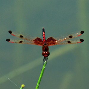
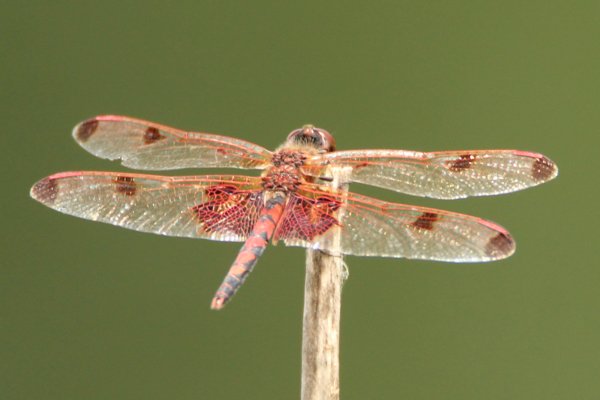
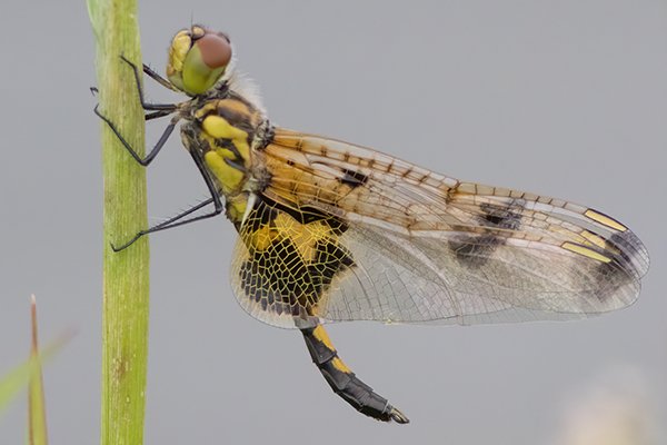
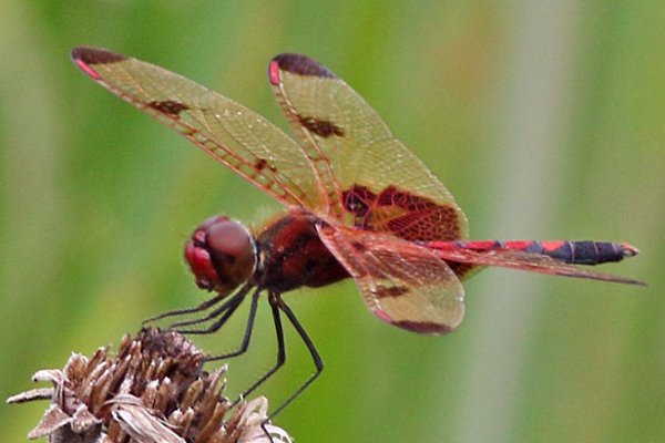
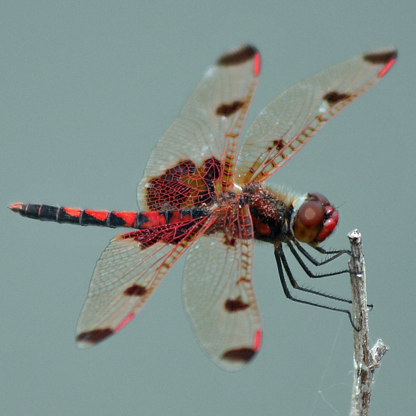
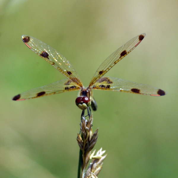
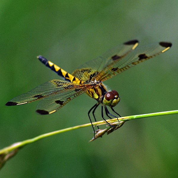
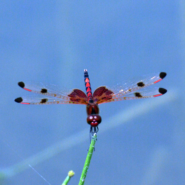
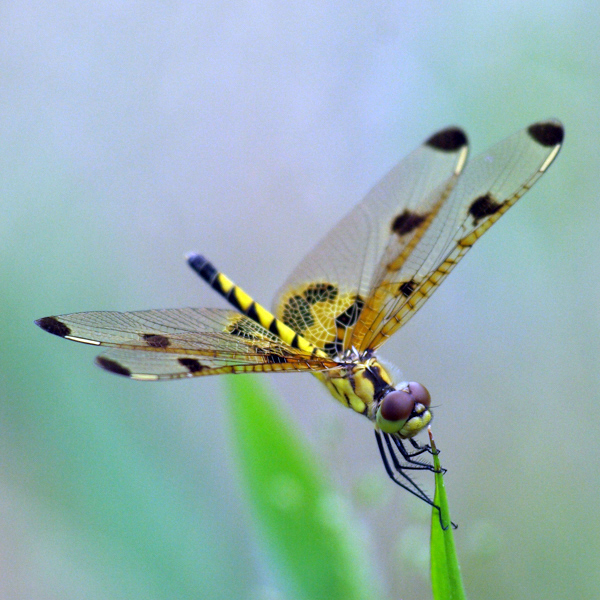
Calico Pennant (Celithemis elisa), (Hagen, 1861)


Photos


Records
| Record # | Date | Locale | State | Lat/Lon | Collected By | Count |
|---|---|---|---|---|---|---|
 345048 345048
|
2023-07-22 | F. W. Kent Park | Iowa | 41.731257 -91.726143 | Mark Brown | 1 |
 345591 345591
|
2023-07-08 | Slip Bluff County Park | Iowa | 40.652884 -93.847544 | Jay Gilliam | 9 |
| 345859 | 2023-07-02 | Fairview Area | Iowa | 43.229133 -96.482404 | Jay Gilliam | 1 |
 345535 345535
|
2023-06-24 | Shimek State Forest, Donnellson Unit | Iowa | 40.633491 -91.667371 | Jay Gilliam | 2 |
| 345744 | 2023-06-24 | Eldon Wildlife Management Area | Iowa | 40.880576 -92.25189 | Jay Gilliam | 3 |
| 345783 | 2023-06-24 | Shimek State Forest, Donnellson Unit | Iowa | 40.645219 -91.667542 | Jay Gilliam | 1 |
 345514 345514
|
2023-06-17 | Slip Bluff County Park | Iowa | 40.652884 -93.847544 | Jay Gilliam | 60 |
| 345656 | 2023-06-10 | Chichaqua Bottoms- Clingan Grassland Unit | Iowa | 41.777616 -93.355846 | Jay Gilliam | 2 |
| 345673 | 2023-06-10 | Slip Bluff County Park | Iowa | 40.652884 -93.847544 | Jay Gilliam | 25 |
| 319357 | 2022-08-14 | Slip Bluff County Park | Iowa | 40.652884 -93.847544 | Jay Gilliam | 4 |
| 319301 | 2022-07-24 | Slip Bluff County Park | Iowa | 40.652884 -93.847544 | Jay Gilliam | 15 |
 317671 317671
|
2022-07-04 | Brushy Creek State Recreation Area | Iowa | 42.381956 -93.975159 | Mark Brown | 1 |
| 319246 | 2022-07-03 | Slip Bluff County Park | Iowa | 40.652884 -93.847544 | Jay Gilliam | 25 |
 316335 316335
|
2022-07-02 | Schwab-Buford Preserve | Iowa | 41.75284246 -91.53385205 | Mark Brown | 1 |
 319143 319143
|
2022-06-30 | Deer Creek Wildlife Management Area | Iowa | 42.718031 -96.511437 | Jay Gilliam | 10 |
| 319014 | 2022-06-18 | Ross Park and Recreation Area | Iowa | 40.607809 -94.963748 | Jay Gilliam | 9 |
| 319029 | 2022-06-18 | Slip Bluff County Park | Iowa | 40.652884 -93.847544 | Jay Gilliam | 12 |
 318979 318979
|
2022-06-12 | Slip Bluff County Park | Iowa | 40.652884 -93.847544 | Jay Gilliam | 1 |
 318930 318930
|
2022-06-05 | Slip Bluff County Park | Iowa | 40.652884 -93.847544 | Jay Gilliam | 100 |
 318846 318846
|
2022-05-28 | Slip Bluff County Park | Iowa | 40.652884 -93.847544 | Jay Gilliam | 11 |
| 301999 | 2021-08-07 | Slip Bluff County Park | Iowa | 40.652884 -93.847544 | Jay Gilliam | 2 |
| 301975 | 2021-08-01 | Eldon Wildlife Management Area | Iowa | 40.880576 -92.25189 | Jay Gilliam | 3 |
| 301931 | 2021-07-25 | Slip Bluff County Park | Iowa | 40.652884 -93.847544 | Jay Gilliam | 6 |
| 301890 | 2021-07-18 | Slip Bluff County Park | Iowa | 40.652884 -93.847544 | Jay Gilliam | 6 |
| 301875 | 2021-07-16 | Slip Bluff County Park | Iowa | 40.652884 -93.847544 | Jay Gilliam | 10 |
| 301782 | 2021-07-04 | Osborne Pond | Iowa | 42.797229 -91.434727 | Jay Gilliam | 1 |
| 294895 | 2021-06-14 | Haupert CRP-x | Iowa | 41.164476 -94.848828 | Ryan Pate | 1 |
 301558 301558
|
2021-06-12 | Eldon Wildlife Management Area | Iowa | 40.880576 -92.25189 | Jay Gilliam | 20 |
| 294871 | 2021-06-11 | Hitchcock Nature Center | Iowa | 41.401411 -95.86093 | Suzanne Gucciardo | 1 |
| 301545 | 2021-06-06 | Chichaqua Bottoms- Clingan Grassland Unit | Iowa | 41.777616 -93.355846 | Jay Gilliam | 12 |
| 301524 | 2021-06-06 | Eldon Wildlife Management Area | Iowa | 40.880576 -92.25189 | Jay Gilliam | 30 |
| 294756 | 2021-06-05 | Slip Bluff County Park | Iowa | 40.65212 -93.84538 | Jay Gilliam | 1 |
 301477 301477
|
2021-06-05 | Slip Bluff County Park | Iowa | 40.652884 -93.847544 | Jay Gilliam | 58 |
| 294743 | 2021-05-31 | Wilcox Wildlife Area | Iowa | 41.23809 -92.96005 | Jay Gilliam | 1 |
 301476 301476
|
2021-05-31 | Wilcox Wildlife Area | Iowa | 41.238081 -92.956863 | Jay Gilliam | 1 |
 290202 290202
|
2021-05-21 | Eldon Wildlife Management Area | Iowa | 40.887971 -92.253072 | Mark Brown | 1 |
| 294698 | 2021-05-21 | Eldon Wildlife Management Area | Iowa | 40.887477 -92.250549 | Mark Brown | 1 |
| 277602 | 2020-08-22 | Slip Bluff County Park | Iowa | 40.652884 -93.847544 | Jay Gilliam | 1 |
| 294574 | 2020-08-22 | Slip Bluff County Park | Iowa | 40.65212 -93.84538 | Jay Gilliam | 1 |
 276816 276816
|
2020-07-28 | Slip Bluff County Park | Iowa | 40.652884 -93.847544 | Jay Gilliam | 1 |
| 294505 | 2020-07-28 | Slip Bluff County Park | Iowa | 40.65212 -93.84538 | Jay Gilliam | 1 |
 276758 276758
|
2020-07-13 | Slip Bluff County Park | Iowa | 40.652884 -93.847544 | Jay Gilliam | 1 |
| 294299 | 2020-07-13 | Slip Bluff County Park | Iowa | 40.65212 -93.84538 | Jay Gilliam | 1 |
| 294059 | 2020-07-07 | Three Waters Wildlife Area | Iowa | 42.64294 -95.04564 | Steve Hummel | 1 |
| 277293 | 2020-06-26 | Chichaqua Bottoms- Clingan Grassland Unit | Iowa | 41.777616 -93.355846 | Jay Gilliam | 1 |
| 294160 | 2020-06-26 | Chichaqua Bottoms- Clingan Grassland Unit | Iowa | 41.777119 -93.357308 | Jay Gilliam | 1 |
 276664 276664
|
2020-06-23 | Slip Bluff County Park | Iowa | 40.652884 -93.847544 | Jay Gilliam | 1 |
| 293755 | 2020-06-23 | Auburn Pits | Iowa | 42.291307 -94.888522 | Steve Hummel | 1 |
| 294025 | 2020-06-23 | Slip Bluff County Park | Iowa | 40.65212 -93.84538 | Jay Gilliam | 1 |
 276579 276579
|
2020-06-12 | Slip Bluff County Park | Iowa | 40.652884 -93.847544 | Jay Gilliam | 1 |
| 293862 | 2020-06-12 | Slip Bluff County Park | Iowa | 40.65212 -93.84538 | Jay Gilliam | 1 |
 276571 276571
|
2020-06-11 | Wilcox Wildlife Area | Iowa | 41.238081 -92.956863 | Jay Gilliam | 1 |
| 293845 | 2020-06-11 | Wilcox Wildlife Area | Iowa | 41.23809 -92.96005 | Jay Gilliam | 1 |
 276521 276521
|
2020-06-04 | Slip Bluff County Park | Iowa | 40.652884 -93.847544 | Jay Gilliam | 10 |
| 293670 | 2020-06-04 | Slip Bluff County Park | Iowa | 40.65212 -93.84538 | Jay Gilliam | 1 |
| 277029 | 2020-05-31 | Annett Nature Center Park | Iowa | 41.298771 -93.576388 | Jay Gilliam | 1 |
| 293625 | 2020-05-31 | Annett Nature Center Park | Iowa | 41.297396 -93.578807 | Jay Gilliam | 1 |
 276494 276494
|
2020-05-30 | Slip Bluff County Park | Iowa | 40.652884 -93.847544 | Jay Gilliam | 1 |
| 293595 | 2020-05-30 | Slip Bluff County Park | Iowa | 40.65212 -93.84538 | Jay Gilliam | 1 |
 276485 276485
|
2020-05-29 | Wilcox Wildlife Area | Iowa | 41.238081 -92.956863 | Jay Gilliam | 2 |
| 293580 | 2020-05-29 | Wilcox Wildlife Area | Iowa | 41.23809 -92.96005 | Jay Gilliam | 1 |
 276593 276593
|
2019-08-26 | Terra Park | Iowa | 41.66229 -93.706763 | Jay Gilliam | 1 |
| 293468 | 2019-08-26 | Terra Park | Iowa | 41.66221 -93.7078 | Jay Gilliam | 1 |
| 293438 | 2019-08-22 | Wilcox Wildlife Area | Iowa | 41.23917 -92.95306 | Marla Mertz | 1 |
 231552 231552
|
2019-06-11 | Big Sand Mound Prairie Preserve, Louisa County | Iowa | 41.331464 -91.082392 | Jim Durbin | 1 |
 231558 231558
|
2019-06-11 | Big Sand Mound Prairie Preserve, Louisa County | Iowa | 41.331464 -91.082392 | Jim Durbin | 1 |
 247489 247489
|
2018-07-08 | Chain Lakes County Park | Iowa | 42.059065 -91.763772 | Don Ohde | 1 |
| 293330 | 2018-07-08 | Pleasant Creek State Recreation Area, Linn County | Iowa | 42.11958 -91.81988 | Don Ohde | 1 |
 202621 202621
|
2017-07-30 | Slip Bluff County Park | Iowa | 40.65255 -93.84534 | Mark Brown | 1 |
| 358815 | 2014-08-13 | Spirit Knoll State Preserve | Iowa | 42.595833 -96.489 | Kirk J. Larsen | 1 |
| 293105 | 2014-07-07 | Harrier Marsh | Iowa | 42.02271 -94.01728 | Matt Stephenson | 1 |
| 293092 | 2014-06-16 | Slip Bluff County Park | Iowa | 40.6547 -93.85162 | Brenda D. Smith | 1 |
 229294 229294
|
2013-06-25 | Ada Hayden Heritage Park | Iowa | 42.06694 -93.62944 | Wolfgang Oesterreich | 1 |
| 292636 | 2011-06-28 | Sedan Bottoms Wildlife Management Area | Iowa | 40.66358 -92.79576 | IOWADNRMSIM | 1 |
| 292611 | 2010-07-10 | Port Louisa National Wildlife Refuge, Horseshoe Bend | Iowa | 41.10954 -91.07771 | rdrass18 | 1 |
 19781 19781
|
2010-06-16 | Leon's Farm, Ohio County | Kentucky | 37.42033 -86.77023 | Jim Durbin | 1 |
 19782 19782
|
2010-06-16 | Leon's Farm, Ohio County | Kentucky | 37.42033 -86.77023 | Jim Durbin | 1 |
 227794 227794
|
2010-06-16 | Leon's Farm, Ohio County | Kentucky | 37.42033 -86.77023 | Jim Durbin | 1 |
 227795 227795
|
2010-06-16 | Leon's Farm, Ohio County | Kentucky | 37.42033 -86.77023 | Jim Durbin | 1 |
 227796 227796
|
2010-06-16 | Leon's Farm, Ohio County | Kentucky | 37.42033 -86.77023 | Jim Durbin | 1 |
| 292608 | 2010-06-13 | Clearview Prairie | Iowa | 40.76809 -92.41216 | rdrass18 | 1 |
| 292670 | 2009-07-08 | Junction of Little Sioux River and 580th St | Iowa | 42.67602 -95.56816 | IOWADNRMSIM | 1 |
 19777 19777
|
2009-06-13 | Leon's Farm, Ohio County | Kentucky | 37.42033 -86.77023 | Jim Durbin | 1 |
 19778 19778
|
2009-06-13 | Leon's Farm, Ohio County | Kentucky | 37.42033 -86.77023 | Jim Durbin | 1 |
 19779 19779
|
2009-06-13 | Leon's Farm, Ohio County | Kentucky | 37.42033 -86.77023 | Jim Durbin | 1 |
 19780 19780
|
2009-06-13 | Leon's Farm, Ohio County | Kentucky | 37.42033 -86.77023 | Jim Durbin | 1 |
 19787 19787
|
2009-06-13 | Leon's Farm, Ohio County | Kentucky | 37.42033 -86.77023 | Jim Durbin | 1 |
 19788 19788
|
2009-06-13 | Leon's Farm, Ohio County | Kentucky | 37.42033 -86.77023 | Jim Durbin | 1 |
 19789 19789
|
2009-06-13 | Leon's Farm, Ohio County | Kentucky | 37.42033 -86.77023 | Jim Durbin | 1 |
 201874 201874
|
2009-06-13 | Leon's Farm, Ohio County | Kentucky | 37.42033 -86.77023 | Jim Durbin | 1 |
 201875 201875
|
2009-06-13 | Leon's Farm, Ohio County | Kentucky | 37.42033 -86.77023 | Jim Durbin | 1 |
 227686 227686
|
2009-06-13 | Leon's Farm, Ohio County | Kentucky | 37.42033 -86.77023 | Jim Durbin | 1 |
 227697 227697
|
2009-06-13 | Leon's Farm, Ohio County | Kentucky | 37.42033 -86.77023 | Jim Durbin | 1 |
 227698 227698
|
2009-06-13 | Leon's Farm, Ohio County | Kentucky | 37.42033 -86.77023 | Jim Durbin | 1 |
 227699 227699
|
2009-06-13 | Leon's Farm, Ohio County | Kentucky | 37.42033 -86.77023 | Jim Durbin | 1 |
 227701 227701
|
2009-06-13 | Leon's Farm, Ohio County | Kentucky | 37.42033 -86.77023 | Jim Durbin | 1 |
 227711 227711
|
2009-06-13 | Leon's Farm, Ohio County | Kentucky | 37.42033 -86.77023 | Jim Durbin | 1 |
 227716 227716
|
2009-06-13 | Leon's Farm, Ohio County | Kentucky | 37.42033 -86.77023 | Jim Durbin | 1 |
 227718 227718
|
2009-06-13 | Leon's Farm, Ohio County | Kentucky | 37.42033 -86.77023 | Jim Durbin | 1 |
 227721 227721
|
2009-06-13 | Leon's Farm, Ohio County | Kentucky | 37.42033 -86.77023 | Jim Durbin | 1 |
 227725 227725
|
2009-06-13 | Leon's Farm, Ohio County | Kentucky | 37.42033 -86.77023 | Jim Durbin | 1 |
 227743 227743
|
2009-06-13 | Leon's Farm, Ohio County | Kentucky | 37.42033 -86.77023 | Jim Durbin | 1 |
 276623 276623
|
2006-06-25 | Rathbun State Wildlife Area | Iowa | 40.902845 -93.174463 | Jay Gilliam | 1 |
| 292213 | 2006-06-25 | Stephens State Forest- Mine Pond | Iowa | 41.000124 -93.4781 | Ann Johnson | 1 |
| 19774 | 2005-06-06 | Leon's Farm, Ohio County | Kentucky | 37.42033 -86.77023 | Jim Durbin | 1 |
| 19775 | 2005-06-06 | Leon's Farm, Ohio County | Kentucky | 37.42033 -86.77023 | Jim Durbin | 1 |
| 19776 | 2005-06-06 | Leon's Farm, Ohio County | Kentucky | 37.42033 -86.77023 | Jim Durbin | 1 |
| 19771 | 2004-07-04 | Leon's Farm, Ohio County | Kentucky | 37.42033 -86.77023 | Jim Durbin | 1 |
| 19772 | 2004-07-04 | Leon's Farm, Ohio County | Kentucky | 37.42033 -86.77023 | Jim Durbin | 1 |
| 19773 | 2004-07-04 | Leon's Farm, Ohio County | Kentucky | 37.42033 -86.77023 | Jim Durbin | 1 |
| 154959 | 2002-07-02 | Kounty Pond - Hoffman Woods Area 2 | Iowa | 42.304357 -91.966967 | Bob Cruden | 1 |
| 159978 | 2001-06-10 | Osborne Outdoor Education Center Park | Iowa | 42.79303 -91.4432 | Bob Cruden | 1 |
| 165969 | 2000-08-14 | Wilson Lake Park | Iowa | 40.644037 -91.490595 | Bob Cruden | 1 |
| 150107 | 2000-07-31 | Calhoun Wildlife Area | Iowa | 42.51695 -94.453482 | Bob Cruden | 1 |
| 160355 | 2000-07-31 | Webster County | Iowa | 42.397495 -94.151375 | Bob Cruden | 1 |
| 163055 | 2000-07-11 | Spring Valley Subdivision Pond | Iowa | 41.710297 -91.562658 | Bob Cruden | 1 |
| 161235 | 2000-06-08 | Van Buren County, Iowa | Iowa | Location Protected | Bob Cruden | 1 |
| 153633 | 1999-08-27 | Green Pines Wildlife Area | Iowa | 41.148068 -93.705678 | Bob Cruden | 1 |
| 153487 | 1999-08-14 | Fayette County | Iowa | 42.925819 -91.909927 | Bob Cruden | 1 |
| 156558 | 1999-07-28 | Madison County | Iowa | 41.4564309 -93.978702 | Bob Cruden | 1 |
| 152842 | 1999-07-17 | Florence Recreation Area | Iowa | 43.377357 -93.851967 | Bob Cruden | 1 |
| 159448 | 1999-07-15 | Pocahontas County | Iowa | 42.691803 -94.645035 | Bob Cruden | 1 |
| 159462 | 1999-07-15 | Pocahontas County | Iowa | 42.691803 -94.645035 | Bob Cruden | 1 |
| 162417 | 1999-07-15 | Humboldt County | Iowa | 42.74826 -94.192337 | Bob Cruden | 1 |
| 161203 | 1999-07-13 | Franklin County | Iowa | 42.737236 -93.33889 | Bob Cruden | 1 |
| 164550 | 1999-07-13 | Toft County Park | Iowa | 42.666887 -93.493708 | Bob Cruden | 1 |
| 160958 | 1999-07-10 | Ross Park and Recreation Area | Iowa | 40.609431 -94.963497 | Bob Cruden | 1 |
| 165405 | 1999-07-08 | Polk County | Iowa | 41.627842 -93.500343 | Bob Cruden | 1 |
| 158858 | 1999-06-24 | Fayette County | Iowa | 42.925819 -91.909927 | Bob Cruden | 1 |
| 158859 | 1999-06-24 | Fayette County | Iowa | 42.925819 -91.909927 | Bob Cruden | 1 |
| 166261 | 1999-06-21 | Yellow River State Forest | Iowa | 43.17457 -91.22317 | Bob Cruden | 1 |
| 163086 | 1999-06-20 | Spring Valley Subdivision Pond | Iowa | 41.710297 -91.562658 | Bob Cruden | 1 |
| 148867 | 1999-06-19 | Cedar County | Iowa | 41.834614 -91.1353 | Bob Cruden | 1 |
| 166319 | 1999-06-08 | Lake Yenruogis County Park | Iowa | 41.37834 -92.2024 | Bob Cruden | 1 |
| 161172 | 1998-08-18 | Muscatine County | Iowa | 41.51569 -91.1353 | Bob Cruden | 1 |
| 161123 | 1998-08-09 | Fayette County | Iowa | 42.925819 -91.909927 | Bob Cruden | 1 |
| 158721 | 1998-07-31 | Mahaska County | Iowa | 41.32959 -92.698387 | Bob Cruden | 1 |
| 156121 | 1998-07-25 | Junction of 225th St and Lake Rd | Iowa | 42.723705 -92.605454 | Bob Cruden | 1 |
| 159916 | 1998-07-25 | Floyd County | Iowa | 43.061596 -92.857712 | Bob Cruden | 1 |
| 159917 | 1998-07-25 | Floyd County | Iowa | 43.061596 -92.857712 | Bob Cruden | 1 |
| 159799 | 1998-07-17 | Osborne Pond | Iowa | 42.797481 -91.434949 | Bob Cruden | 1 |
| 159824 | 1998-07-03 | Henry County | Iowa | 41.028358 -91.598396 | Bob Cruden | 1 |
| 154381 | 1998-07-02 | Iowa Township Park | Iowa | 41.48502 -91.581131 | Bob Cruden | 1 |
| 154382 | 1998-07-02 | Iowa Township Park | Iowa | 41.48502 -91.581131 | Bob Cruden | 1 |
| 160569 | 1998-07-01 | Junction of Hwy 218 and W Cedar Wapsi Rd | Iowa | 42.611986 -92.4405 | Bob Cruden | 1 |
| 150671 | 1998-06-23 | Central Park, Jones County | Iowa | 42.11112 -91.13904 | Bob Cruden | 1 |
| 151315 | 1998-06-21 | Crow Creek Wildlife Management Area | Iowa | 41.612748 -90.559036 | Bob Cruden | 1 |
| 154912 | 1998-05-31 | Meadow Lake Campground | Iowa | 41.712085 -91.09573 | Bob Cruden | 1 |
| 166385 | 1998-05-28 | Lake Yenruogis County Park | Iowa | 41.37834 -92.2024 | Bob Cruden | 1 |
| 166360 | 1997-09-17 | Lake Yenruogis County Park | Iowa | 41.37834 -92.2024 | Bob Cruden | 1 |
| 165758 | 1997-09-04 | Wilcox Wildlife Area | Iowa | 41.236395 -92.961746 | Bob Cruden | 1 |
| 166037 | 1997-08-04 | Wilson Lake Park | Iowa | 40.644037 -91.490595 | Bob Cruden | 1 |
| 166038 | 1997-08-04 | Wilson Lake Park | Iowa | 40.644037 -91.490595 | Bob Cruden | 1 |
| 158751 | 1997-07-18 | Sac County | Iowa | 42.357353 -95.143204 | Bob Cruden | 1 |
| 161620 | 1997-07-17 | Osceola County | Iowa | 43.385197 -95.603745 | Bob Cruden | 1 |
| 154750 | 1997-06-30 | Killdeer County Park | Iowa | 41.817187 -90.450027 | Bob Cruden | 1 |
| 156157 | 1997-06-26 | Large Farm Pond on Hwy 34 | Iowa | 41.027123 -94.081519 | Bob Cruden | 1 |
| 159941 | 1997-06-23 | Floyd County | Iowa | 43.061596 -92.857712 | Bob Cruden | 1 |
| 166373 | 1997-06-01 | Lake Yenruogis County Park | Iowa | 41.37834 -92.2024 | Bob Cruden | 1 |
| 153370 | 1996-08-22 | Carmack County Park | Iowa | 41.119941 -92.934515 | Bob Cruden | 1 |
| 165743 | 1996-08-12 | Wilcox Wildlife Area | Iowa | 41.234292 -92.958631 | Bob Cruden | 1 |
| 166419 | 1996-08-03 | Lake Yenruogis County Park | Iowa | 41.37834 -92.2024 | Bob Cruden | 1 |
| 161893 | 1996-07-17 | Siems County Park | Iowa | 43.055586 -94.398397 | Bob Cruden | 1 |
| 160090 | 1996-07-05 | Spring Valley Subdivision Pond | Iowa | 41.710348 -91.562685 | Bob Cruden | 1 |
| 165527 | 1995-08-04 | White Oak Conservation Area | Iowa | 41.2697222 -92.4747222 | Bob Cruden | 1 |
| 166397 | 1995-08-04 | Lake Yenruogis County Park | Iowa | 41.37834 -92.2024 | Bob Cruden | 1 |
| 159378 | 1995-07-28 | Pioneer Ridge Nature Area | Iowa | 40.902552 -92.407392 | Bob Cruden | 1 |
| 159622 | 1995-07-27 | Pollmiller Park | Iowa | 40.712972 -91.437922 | Bob Cruden | 1 |
| 161638 | 1995-07-26 | Seven Ponds Park | Iowa | 40.961638 -91.131563 | Bob Cruden | 1 |
| 166340 | 1995-07-08 | Lake Yenruogis County Park | Iowa | 41.37834 -92.2024 | Bob Cruden | 1 |
| 166297 | 1995-06-29 | Lake Yenruogis County Park | Iowa | 41.37834 -92.2024 | Bob Cruden | 1 |
| 155088 | 1995-06-19 | Kounty Pond - Hoffman Woods Area 2 | Iowa | 42.304357 -91.966967 | Bob Cruden | 1 |
| 156891 | 1994-06-27 | Lizard Creek @ 330th Ave | Iowa | 42.63923 -94.4628 | Bob Cruden | 1 |
| 292581 | 1974-07-07 | Crow Creek Park, Bettendorf | Iowa | 41.57092 -90.47655 | Steve Hummel | 1 |
| 292483 | 1971-07-05 | University of Northern Iowa | Iowa | 42.51338 -92.4622 | Steve Hummel | 1 |